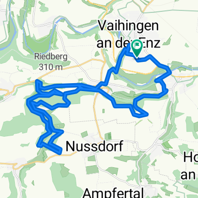
Kreuzbachroute Sonnenberg Großglattbach
- 27.6 km
- 368 m
- 366 m
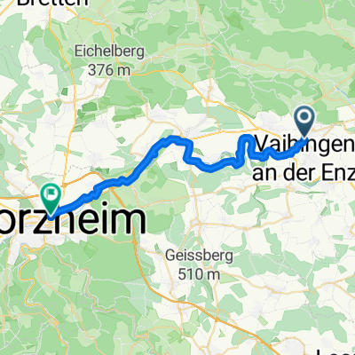
- Vaihingen an der Enz, Baden-Wurttemberg, Germany
A cycling route starting in Vaihingen an der Enz, Baden-Wurttemberg, Germany.
Overview
Vaihingen – Sersheim 30.0 km
The tour starts at the Vaihingen train station. Follow the bike path along the main road to the left, first following the Stromberg-Murrtal route towards Vaihingen, then towards Bietigheim. Continue straight over the district road, at the bus turning area continue straight onto the farm road.
At the T-junction turn left, continue straight over the district road, then downhill into the valley. Follow the stream upstream along the valley, then right and follow the path to the bike path and along the L1125. At the second bike trail junction turn right and go straight downhill towards the Enztal-Weg.
At the entrance of Untermberg turn right, continue downhill, cross the district road and descend the hill ridge down to the Enz. There, follow the Enztal-Weg to the left.
At the entrance of Untermberg veer slightly right, take the bike/pedestrian path along the dike. At the end turn right, cross the bridge and on ‘Flößerstraße’ turn left into Bissingen. Turn left onto the bike/pedestrian path and at the parking lot veer slightly right on the paved path under the bridge and along the Enz towards Bietigheim.
On ‘Wobachstraße’ descend about 100 m to the left, then left over the bridgeand through the park. Slightly left onto ‘Fischerpfad’ gently uphill.
Past the parking lot, cross the street and take the bike/pedestrian path through the residential area. Straight over the bridge, then right about 200 m parallel to the main road. Left onto the farm road and straight to Sachsenheim.
On the bridge over the main road, straight on the next main road, at the T-junction left and on the bridge over the bypass. Right and parallel to L1125. At the next junction straight over the main road and on the bike path towards Großsachsenheim.
Follow the farm road along the outskirts. Shortly before the tracks, left on the farm road, gently uphill, soon straight through the woods, then parallel to the tracks towards Sersheim.
Sersheim – Vaihingen 19.5 km
At the T-junction turn right, through the underpass and onto ‘Bahnhofstraße’ into town. Straight into ‘Schlossstraße’, right into ‘Bädergasse’, left into ‘Metter Straße’, straight over the main road and out of town along the farm road in the valley.
Follow the Metter upstream towards Horrheim. Straight on ‘Klosterbergstraße’ through town, over L1106 into ‘St. Leonhard Straße’, right into ‘Plattenweg’, straight over the bridge to the other side of the valley and there follow the road left out of town.
Shortly before the T-junction right onto the farm road and parallel to L1131 in the valley towards Gündelbach. Straight on ‘Reutwiesenstraße’ into town. Straight on ‘Schützinger Straße’ and the next left into ‘Steinbruchweg’.
After the bridge right into the bend and follow the Metter upstream along the slope towards Schützingen. At the entrance of town left into ‘Ringstraße’ and uphill along the stream out of town. Left to the district road, then right and up the bike path along the district road.
At the height, after crossing the railway line, left on the farm road and down the gravel path into the valley. There left, past the ponds,straight into Illingen.
On ‘Einsiedlerweg’ through the residential area, right downhill on ‘Neuhalde’, at the T-junction left and the next right on the bike/pedestrian path through the valley to and through the underpass.
After the underpass the second left and along the stream into town. Across the main road continuing along the Schmie.
Over the bridge, on the main road left, the next right uphill into ‘Uhlandstraße’, right into ‘Kernerstraße’, right to the roundaboutand on the bike path along K4579 out of town. At the bike trail junction before the bridge veer slightly right, follow the bike path back to the tour start point.
created this 13 years ago
Route quality
Track
33.6 km
(68 %)
Quiet road
6.9 km
(14 %)
Paved
42.6 km
(86 %)
Unpaved
4.9 km
(10 %)
Asphalt
37.1 km
(75 %)
Paved (undefined)
5.4 km
(11 %)
Continue with Bikemap
You would like to ride Mettertal-Tour or customize it for your own trip? Here is what you can do with this Bikemap route:
Free trial for 3 days, or one-time payment. More about Bikemap Premium.
Discover more Premium features.
Get Bikemap PremiumFrom our community
Open it in the app