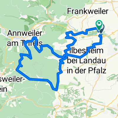
Sbd-Edenk. Schänzel-Ramburg-Sbd
A cycling route starting in Siebeldingen, Rhineland-Palatinate, Germany.
Overview
About this route
- -:--
- Duration
- 39.4 km
- Distance
- 877 m
- Ascent
- 866 m
- Descent
- ---
- Avg. speed
- 591 m
- Avg. speed
Route quality
Waytypes & surfaces along the route
Waytypes
Busy road
16.4 km
(42 %)
Quiet road
10 km
(25 %)
Surfaces
Paved
35.4 km
(90 %)
Unpaved
2.5 km
(6 %)
Asphalt
34.1 km
(86 %)
Gravel
2 km
(5 %)
Continue with Bikemap
Use, edit, or download this cycling route
You would like to ride Sbd-Edenk. Schänzel-Ramburg-Sbd or customize it for your own trip? Here is what you can do with this Bikemap route:
Free features
- Save this route as favorite or in collections
- Copy & plan your own version of this route
- Sync your route with Garmin or Wahoo
Premium features
Free trial for 3 days, or one-time payment. More about Bikemap Premium.
- Navigate this route on iOS & Android
- Export a GPX / KML file of this route
- Create your custom printout (try it for free)
- Download this route for offline navigation
Discover more Premium features.
Get Bikemap PremiumFrom our community
Other popular routes starting in Siebeldingen
- WILGARTSWIESEN
- Distance
- 43.1 km
- Ascent
- 353 m
- Descent
- 353 m
- Location
- Siebeldingen, Rhineland-Palatinate, Germany
- Im Trifelsland
- Distance
- 47.5 km
- Ascent
- 728 m
- Descent
- 725 m
- Location
- Siebeldingen, Rhineland-Palatinate, Germany
- Dahn Rennrad
- Distance
- 87.9 km
- Ascent
- 1,213 m
- Descent
- 1,216 m
- Location
- Siebeldingen, Rhineland-Palatinate, Germany
- Sbd-Edenk. Schänzel-Ramburg-Sbd
- Distance
- 39.4 km
- Ascent
- 877 m
- Descent
- 866 m
- Location
- Siebeldingen, Rhineland-Palatinate, Germany
- Route von In der Plöck 18, Landau in der Pfalz
- Distance
- 28.9 km
- Ascent
- 48 m
- Descent
- 104 m
- Location
- Siebeldingen, Rhineland-Palatinate, Germany
- RLP15a: Siebeldingen - Neuburg a.Rhein 82.2km 207hm
- Distance
- 82.2 km
- Ascent
- 207 m
- Descent
- 249 m
- Location
- Siebeldingen, Rhineland-Palatinate, Germany
- Lambrecht_Totenkopfhütte
- Distance
- 66.4 km
- Ascent
- 902 m
- Descent
- 899 m
- Location
- Siebeldingen, Rhineland-Palatinate, Germany
- siebeldingen-ramberg-siebeldingen 24km
- Distance
- 24.1 km
- Ascent
- 309 m
- Descent
- 306 m
- Location
- Siebeldingen, Rhineland-Palatinate, Germany
Open it in the app