

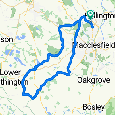
Prestbury Court, Castle Rise, Macclesfield to Prestbury Court, Castle Rise, Macclesfield
A cycling route starting in Prestbury, England, United Kingdom.
Overview
About this route
- 30 min
- Duration
- 10.4 km
- Distance
- 137 m
- Ascent
- 139 m
- Descent
- 21 km/h
- Avg. speed
- 168 m
- Max. altitude

Route quality
Waytypes & surfaces along the route
Waytypes
Quiet road
4.2 km
(40 %)
Busy road
3.8 km
(37 %)
Surfaces
Paved
5.2 km
(50 %)
Asphalt
5.2 km
(50 %)
Undefined
5.2 km
(50 %)
Continue with Bikemap
Use, edit, or download this cycling route
You would like to ride Prestbury Court, Castle Rise, Macclesfield to Prestbury Court, Castle Rise, Macclesfield or customize it for your own trip? Here is what you can do with this Bikemap route:
Free features
- Save this route as favorite or in collections
- Copy & plan your own version of this route
- Sync your route with Garmin or Wahoo
Premium features
Free trial for 3 days, or one-time payment. More about Bikemap Premium.
- Navigate this route on iOS & Android
- Export a GPX / KML file of this route
- Create your custom printout (try it for free)
- Download this route for offline navigation
Discover more Premium features.
Get Bikemap PremiumFrom our community
Other popular routes starting in Prestbury
 The Dog
- Distance
- 14.1 km
- Ascent
- 82 m
- Descent
- 129 m
- Location
- Prestbury, England, United Kingdom
 sunday 31/1/2021
- Distance
- 60 km
- Ascent
- 475 m
- Descent
- 425 m
- Location
- Prestbury, England, United Kingdom
 training circular 2
- Distance
- 40.3 km
- Ascent
- 234 m
- Descent
- 240 m
- Location
- Prestbury, England, United Kingdom
 Suffolk Close 16 to Wood Lane South
- Distance
- 10.9 km
- Ascent
- 158 m
- Descent
- 162 m
- Location
- Prestbury, England, United Kingdom
 Norfolk Walk 1 to Stafford Close 10
- Distance
- 4.5 km
- Ascent
- 0 m
- Descent
- 4 m
- Location
- Prestbury, England, United Kingdom
 Devon Close 27 to Norfolk Walk 1
- Distance
- 5.8 km
- Ascent
- 3 m
- Descent
- 3 m
- Location
- Prestbury, England, United Kingdom
 53 Drummond Way, Macclesfield to Largo do Chafariz 3, Lousa
- Distance
- 5,497.4 km
- Ascent
- 17,153 m
- Descent
- 16,971 m
- Location
- Prestbury, England, United Kingdom
 Willow Trees, Alderley Road, Macclesfield to 84 Knutsford Road, Alderley Edge
- Distance
- 12.2 km
- Ascent
- 116 m
- Descent
- 195 m
- Location
- Prestbury, England, United Kingdom
Open it in the app