

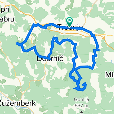
Kozjak, Ostri vrh
A cycling route starting in Trebnje, Trebnje, Slovenia.
Overview
About this route
- -:--
- Duration
- 43.8 km
- Distance
- 820 m
- Ascent
- 820 m
- Descent
- ---
- Avg. speed
- ---
- Max. altitude
Route highlights
Points of interest along the route

Point of interest after 3.4 km
Most nad avtocesto Lj-Nm

Point of interest after 3.7 km
Novo zgrajena cesta iz Belšinje vasi proti Pluski

Point of interest after 5.1 km
Ohranjena in obnovljena slamnato krita hiša

Point of interest after 5.1 km

Point of interest after 6.2 km
Rojstna hiša Friderika Ireneja Barage

Point of interest after 8.7 km
Idilična pokrajina ob vzponu na Kozjek

Point of interest after 9 km
Ekološka kmetija Marinček in razvaline gradu Kozjek

Point of interest after 10.1 km
Štrleči kamni kažejo na kraški svet

Point of interest after 11 km
Čudovita gozdna pot iz Dolenjih Kamenj proti Železnem

Point of interest after 14.5 km
Obnovljen vodnjak v centru Dobrniča

Point of interest after 19 km
Sončna ura na obeležju 15.poldnevnika pri lovski koči na Vrhtrebnjem

Point of interest after 28.7 km
Ostri vrh 523m

Point of interest after 36.3 km
Živina na pašniku
Continue with Bikemap
Use, edit, or download this cycling route
You would like to ride Kozjak, Ostri vrh or customize it for your own trip? Here is what you can do with this Bikemap route:
Free features
- Save this route as favorite or in collections
- Copy & plan your own version of this route
- Sync your route with Garmin or Wahoo
Premium features
Free trial for 3 days, or one-time payment. More about Bikemap Premium.
- Navigate this route on iOS & Android
- Export a GPX / KML file of this route
- Create your custom printout (try it for free)
- Download this route for offline navigation
Discover more Premium features.
Get Bikemap PremiumFrom our community
Other popular routes starting in Trebnje
 Trebnje - Šentvid - Trebnje
- Distance
- 36.1 km
- Ascent
- 332 m
- Descent
- 335 m
- Location
- Trebnje, Trebnje, Slovenia
 Kozjak, Ostri vrh
- Distance
- 43.8 km
- Ascent
- 820 m
- Descent
- 820 m
- Location
- Trebnje, Trebnje, Slovenia
 Trebnje Šmarješke toplice Žužemberk Trebnje
- Distance
- 63.1 km
- Ascent
- 433 m
- Descent
- 433 m
- Location
- Trebnje, Trebnje, Slovenia
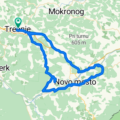 Trebnje - Otočec - Straža - Mirna Peč -Trebnje
- Distance
- 68 km
- Ascent
- 557 m
- Descent
- 557 m
- Location
- Trebnje, Trebnje, Slovenia
 Trebnje Dana 20.junij
- Distance
- 63.9 km
- Ascent
- 334 m
- Descent
- 336 m
- Location
- Trebnje, Trebnje, Slovenia
 Trebnje-Šentrupert-Dole pri Litiji-Gabrovka-Čatež-Trebnje
- Distance
- 47 km
- Ascent
- 724 m
- Descent
- 722 m
- Location
- Trebnje, Trebnje, Slovenia
 trebnje-mirna peč
- Distance
- 40 km
- Ascent
- 620 m
- Descent
- 619 m
- Location
- Trebnje, Trebnje, Slovenia
 Obhod dolenjske
- Distance
- 86 km
- Ascent
- 1,743 m
- Descent
- 1,757 m
- Location
- Trebnje, Trebnje, Slovenia
Open it in the app