

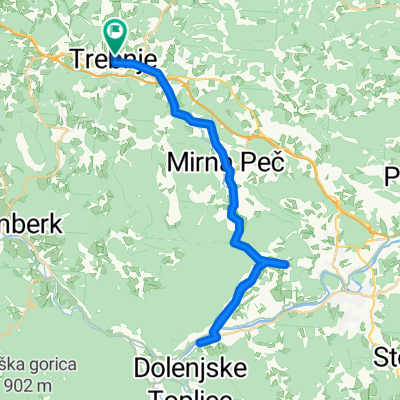
Trebnje-Šentrupert-Dole pri Litiji-Gabrovka-Čatež-Trebnje
A cycling route starting in Trebnje, Trebnje, Slovenia.
Overview
About this route
- -:--
- Duration
- 47 km
- Distance
- 724 m
- Ascent
- 722 m
- Descent
- ---
- Avg. speed
- ---
- Max. altitude
Route quality
Waytypes & surfaces along the route
Waytypes
Quiet road
29.2 km
(62 %)
Road
12.7 km
(27 %)
Undefined
5.2 km
(11 %)
Surfaces
Paved
9.4 km
(20 %)
Asphalt
9.4 km
(20 %)
Undefined
37.6 km
(80 %)
Route highlights
Points of interest along the route
Point of interest after 21.9 km
Slap Bena
Continue with Bikemap
Use, edit, or download this cycling route
You would like to ride Trebnje-Šentrupert-Dole pri Litiji-Gabrovka-Čatež-Trebnje or customize it for your own trip? Here is what you can do with this Bikemap route:
Free features
- Save this route as favorite or in collections
- Copy & plan your own version of this route
- Sync your route with Garmin or Wahoo
Premium features
Free trial for 3 days, or one-time payment. More about Bikemap Premium.
- Navigate this route on iOS & Android
- Export a GPX / KML file of this route
- Create your custom printout (try it for free)
- Download this route for offline navigation
Discover more Premium features.
Get Bikemap PremiumFrom our community
Other popular routes starting in Trebnje
 trebnje, mirna peč, vrhovo, straža, prečna, trebnje
- Distance
- 46.5 km
- Ascent
- 406 m
- Descent
- 406 m
- Location
- Trebnje, Trebnje, Slovenia
 trebnje-mirna peč
- Distance
- 40 km
- Ascent
- 620 m
- Descent
- 619 m
- Location
- Trebnje, Trebnje, Slovenia
 trebnje-trebeljevo-grosuplje-trebnje
- Distance
- 80.8 km
- Ascent
- 808 m
- Descent
- 798 m
- Location
- Trebnje, Trebnje, Slovenia
 Trebnje Dana 20.junij
- Distance
- 63.9 km
- Ascent
- 334 m
- Descent
- 336 m
- Location
- Trebnje, Trebnje, Slovenia
 Trebnje - Letališče Šentvid - Trebnje
- Distance
- 31.8 km
- Ascent
- 385 m
- Descent
- 379 m
- Location
- Trebnje, Trebnje, Slovenia
 Trebnje-Šentrupert-Dole pri Litiji-Gabrovka-Čatež-Trebnje
- Distance
- 47 km
- Ascent
- 724 m
- Descent
- 722 m
- Location
- Trebnje, Trebnje, Slovenia
 Obhod dolenjske
- Distance
- 86 km
- Ascent
- 1,743 m
- Descent
- 1,757 m
- Location
- Trebnje, Trebnje, Slovenia
 Trebnje - Otočec - Straža - Mirna Peč -Trebnje
- Distance
- 68 km
- Ascent
- 557 m
- Descent
- 557 m
- Location
- Trebnje, Trebnje, Slovenia
Open it in the app