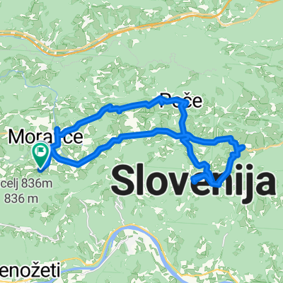
Vaška runda
A cycling route starting in Moravče, Občina Moravče, Slovenia.
Overview
About this route
- -:--
- Duration
- 54.1 km
- Distance
- 504 m
- Ascent
- 504 m
- Descent
- ---
- Avg. speed
- ---
- Avg. speed
Route quality
Waytypes & surfaces along the route
Waytypes
Busy road
49 km
(91 %)
Quiet road
2.2 km
(4 %)
Surfaces
Paved
29.3 km
(54 %)
Unpaved
1.2 km
(2 %)
Asphalt
28.5 km
(53 %)
Gravel
1.2 km
(2 %)
Continue with Bikemap
Use, edit, or download this cycling route
You would like to ride Vaška runda or customize it for your own trip? Here is what you can do with this Bikemap route:
Free features
- Save this route as favorite or in collections
- Copy & plan your own version of this route
- Sync your route with Garmin or Wahoo
Premium features
Free trial for 3 days, or one-time payment. More about Bikemap Premium.
- Navigate this route on iOS & Android
- Export a GPX / KML file of this route
- Create your custom printout (try it for free)
- Download this route for offline navigation
Discover more Premium features.
Get Bikemap PremiumFrom our community
Other popular routes starting in Moravče
- Češnjice-Zasavska sveta gora in nazaj
- Distance
- 28.2 km
- Ascent
- 447 m
- Descent
- 448 m
- Location
- Moravče, Občina Moravče, Slovenia
- Moja trening pot
- Distance
- 33 km
- Ascent
- 342 m
- Descent
- 342 m
- Location
- Moravče, Občina Moravče, Slovenia
- Krašce - "Mozirski gaj"
- Distance
- 112.9 km
- Ascent
- 697 m
- Descent
- 696 m
- Location
- Moravče, Občina Moravče, Slovenia
- Češnjice-Javoršica-Sv.Trojica-Češnjice
- Distance
- 19.8 km
- Ascent
- 577 m
- Descent
- 577 m
- Location
- Moravče, Občina Moravče, Slovenia
- X8do_Krašce - Ajdovščina - N.Gorica - Sežana - Ankaran
- Distance
- 218.5 km
- Ascent
- 1,384 m
- Descent
- 1,715 m
- Location
- Moravče, Občina Moravče, Slovenia
- PD Blagovica_dvonamenska pot_VAR 1
- Distance
- 50.5 km
- Ascent
- 1,394 m
- Descent
- 1,394 m
- Location
- Moravče, Občina Moravče, Slovenia
- moravce dintorni
- Distance
- 38.2 km
- Ascent
- 1,338 m
- Descent
- 1,503 m
- Location
- Moravče, Občina Moravče, Slovenia
- Blagovica - Špilk - Trojane - Golčaj
- Distance
- 20.7 km
- Ascent
- 816 m
- Descent
- 817 m
- Location
- Moravče, Občina Moravče, Slovenia
Open it in the app