

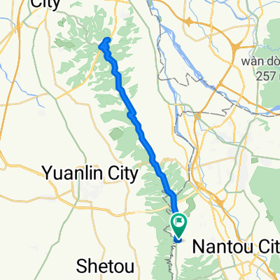
田中-豐柏廣場-受天宮
A cycling route starting in Nantou City, Taiwan, Taiwan.
Overview
About this route
- -:--
- Duration
- 10 km
- Distance
- 413 m
- Ascent
- 80 m
- Descent
- ---
- Avg. speed
- 382 m
- Max. altitude
Route quality
Waytypes & surfaces along the route
Waytypes
Road
3.5 km
(35 %)
Busy road
3.1 km
(31 %)
Surfaces
Paved
3.8 km
(38 %)
Asphalt
3.8 km
(38 %)
Undefined
6.2 km
(62 %)
Continue with Bikemap
Use, edit, or download this cycling route
You would like to ride 田中-豐柏廣場-受天宮 or customize it for your own trip? Here is what you can do with this Bikemap route:
Free features
- Save this route as favorite or in collections
- Copy & plan your own version of this route
- Sync your route with Garmin or Wahoo
Premium features
Free trial for 3 days, or one-time payment. More about Bikemap Premium.
- Navigate this route on iOS & Android
- Export a GPX / KML file of this route
- Create your custom printout (try it for free)
- Download this route for offline navigation
Discover more Premium features.
Get Bikemap PremiumFrom our community
Other popular routes starting in Nantou City
 彰化經典百K 2018/03/24
- Distance
- 112.4 km
- Ascent
- 1,530 m
- Descent
- 1,536 m
- Location
- Nantou City, Taiwan, Taiwan
 田尾-嘉義-阿里山-塔塔加-水里-田尾一日來回300km
- Distance
- 257.7 km
- Ascent
- 2,556 m
- Descent
- 2,556 m
- Location
- Nantou City, Taiwan, Taiwan
 塔塔加
塔塔加- Distance
- 185.6 km
- Ascent
- 2,617 m
- Descent
- 2,668 m
- Location
- Nantou City, Taiwan, Taiwan
 20181201第一次團練-日月山景
- Distance
- 36.1 km
- Ascent
- 346 m
- Descent
- 345 m
- Location
- Nantou City, Taiwan, Taiwan
 埤頭溪湖二林台糖鐵道
- Distance
- 10.3 km
- Ascent
- 150 m
- Descent
- 168 m
- Location
- Nantou City, Taiwan, Taiwan
 員南路
員南路- Distance
- 5.1 km
- Ascent
- 403 m
- Descent
- 24 m
- Location
- Nantou City, Taiwan, Taiwan
 南豐高爾夫至鳳山寺
- Distance
- 3.2 km
- Ascent
- 11 m
- Descent
- 322 m
- Location
- Nantou City, Taiwan, Taiwan
 彰化八卦山脈之九橫一豎
- Distance
- 139.1 km
- Ascent
- 3,245 m
- Descent
- 3,075 m
- Location
- Nantou City, Taiwan, Taiwan
Open it in the app