

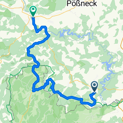
Helmsgrün - Saalburg
A cycling route starting in Bad Lobenstein, Thuringia, Germany.
Overview
About this route
easy route, return a bit more challenging due to the climbs, very nice scenery, highlight - Bleilochtalsperre as the destination
- -:--
- Duration
- 14.3 km
- Distance
- 150 m
- Ascent
- 323 m
- Descent
- ---
- Avg. speed
- ---
- Max. altitude
Route quality
Waytypes & surfaces along the route
Waytypes
Track
8.6 km
(60 %)
Quiet road
4.6 km
(32 %)
Surfaces
Paved
2.7 km
(19 %)
Unpaved
5.9 km
(41 %)
Asphalt
2.3 km
(16 %)
Gravel
2.3 km
(16 %)
Continue with Bikemap
Use, edit, or download this cycling route
You would like to ride Helmsgrün - Saalburg or customize it for your own trip? Here is what you can do with this Bikemap route:
Free features
- Save this route as favorite or in collections
- Copy & plan your own version of this route
- Sync your route with Garmin or Wahoo
Premium features
Free trial for 3 days, or one-time payment. More about Bikemap Premium.
- Navigate this route on iOS & Android
- Export a GPX / KML file of this route
- Create your custom printout (try it for free)
- Download this route for offline navigation
Discover more Premium features.
Get Bikemap PremiumFrom our community
Other popular routes starting in Bad Lobenstein
 Gallenberg
- Distance
- 0.7 km
- Ascent
- 57 m
- Descent
- 0 m
- Location
- Bad Lobenstein, Thuringia, Germany
 2-Talsperren-Tour
- Distance
- 62.4 km
- Ascent
- 766 m
- Descent
- 1,051 m
- Location
- Bad Lobenstein, Thuringia, Germany
 Göltzschtalbrücke - Gravel
- Distance
- 125.9 km
- Ascent
- 1,151 m
- Descent
- 1,151 m
- Location
- Bad Lobenstein, Thuringia, Germany
 Helmsgrün - Saalburg
- Distance
- 14.3 km
- Ascent
- 150 m
- Descent
- 323 m
- Location
- Bad Lobenstein, Thuringia, Germany
 BL-RS
BL-RS- Distance
- 82.8 km
- Ascent
- 789 m
- Descent
- 1,089 m
- Location
- Bad Lobenstein, Thuringia, Germany
 Haxen-tour auf dem Rennsteig
- Distance
- 80.1 km
- Ascent
- 591 m
- Descent
- 841 m
- Location
- Bad Lobenstein, Thuringia, Germany
 route 2 zum bodensee
- Distance
- 155.3 km
- Ascent
- 1,946 m
- Descent
- 2,156 m
- Location
- Bad Lobenstein, Thuringia, Germany
 Frankenwald
- Distance
- 79.6 km
- Ascent
- 652 m
- Descent
- 907 m
- Location
- Bad Lobenstein, Thuringia, Germany
Open it in the app