

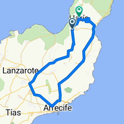
Lanzarote 9
A cycling route starting in Haría, Canary Islands, Spain.
Overview
About this route
Ironman course Lanzarote
- -:--
- Duration
- 143 km
- Distance
- 1,193 m
- Ascent
- 1,197 m
- Descent
- ---
- Avg. speed
- ---
- Max. altitude
Continue with Bikemap
Use, edit, or download this cycling route
You would like to ride Lanzarote 9 or customize it for your own trip? Here is what you can do with this Bikemap route:
Free features
- Save this route as favorite or in collections
- Copy & plan your own version of this route
- Split it into stages to create a multi-day tour
- Sync your route with Garmin or Wahoo
Premium features
Free trial for 3 days, or one-time payment. More about Bikemap Premium.
- Navigate this route on iOS & Android
- Export a GPX / KML file of this route
- Create your custom printout (try it for free)
- Download this route for offline navigation
Discover more Premium features.
Get Bikemap PremiumFrom our community
Other popular routes starting in Haría
 Palo,CostaTeguise,Tahiche,Mala,Palo
- Distance
- 43.1 km
- Ascent
- 366 m
- Descent
- 366 m
- Location
- Haría, Canary Islands, Spain
 Lanzarote 9
- Distance
- 143 km
- Ascent
- 1,193 m
- Descent
- 1,197 m
- Location
- Haría, Canary Islands, Spain
 Lanzarote 3
- Distance
- 113.2 km
- Ascent
- 1,415 m
- Descent
- 1,421 m
- Location
- Haría, Canary Islands, Spain
 LA GRACIOSA COMPLETA
- Distance
- 32.4 km
- Ascent
- 289 m
- Descent
- 287 m
- Location
- Haría, Canary Islands, Spain
 Calle Brezo de Mar, 7, Teguise nach Calle Brezo de Mar, 1, Teguise
- Distance
- 15.3 km
- Ascent
- 786 m
- Descent
- 789 m
- Location
- Haría, Canary Islands, Spain
 80km from Costa Tequise
- Distance
- 81.5 km
- Ascent
- 912 m
- Descent
- 1,206 m
- Location
- Haría, Canary Islands, Spain
 MTB-Tour vom Mirador del Rio zur Costa Calero
- Distance
- 59 km
- Ascent
- 853 m
- Descent
- 1,272 m
- Location
- Haría, Canary Islands, Spain
 From Haría to Yaiza
- Distance
- 106.6 km
- Ascent
- 1,828 m
- Descent
- 2,177 m
- Location
- Haría, Canary Islands, Spain
Open it in the app