

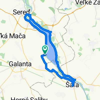
galanta - tomasikovo
A cycling route starting in Galanta, Trnava Region, Slovakia.
Overview
About this route
- 2 h 13 min
- Duration
- 36.9 km
- Distance
- 32 m
- Ascent
- 34 m
- Descent
- 16.7 km/h
- Avg. speed
- 121 m
- Max. altitude

Route quality
Waytypes & surfaces along the route
Waytypes
Track
17.3 km
(47 %)
Quiet road
9.6 km
(26 %)
Surfaces
Paved
8.1 km
(22 %)
Unpaved
7.4 km
(20 %)
Ground
6.3 km
(17 %)
Concrete
4.4 km
(12 %)
Continue with Bikemap
Use, edit, or download this cycling route
You would like to ride galanta - tomasikovo or customize it for your own trip? Here is what you can do with this Bikemap route:
Free features
- Save this route as favorite or in collections
- Copy & plan your own version of this route
- Sync your route with Garmin or Wahoo
Premium features
Free trial for 3 days, or one-time payment. More about Bikemap Premium.
- Navigate this route on iOS & Android
- Export a GPX / KML file of this route
- Create your custom printout (try it for free)
- Download this route for offline navigation
Discover more Premium features.
Get Bikemap PremiumFrom our community
Other popular routes starting in Galanta
 Vozokany-Jelka mlyn-Vozokany
- Distance
- 54.7 km
- Ascent
- 58 m
- Descent
- 102 m
- Location
- Galanta, Trnava Region, Slovakia
 Vozokany-Kráľov Brod-Dolný Chotár-Trstice-Jahodná-Tomašíkovo-Vozokany
- Distance
- 43.6 km
- Ascent
- 20 m
- Descent
- 68 m
- Location
- Galanta, Trnava Region, Slovakia
 Esterházyovcov 6 do Svätoplukovo námestie 1/A
- Distance
- 45.8 km
- Ascent
- 333 m
- Descent
- 310 m
- Location
- Galanta, Trnava Region, Slovakia
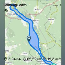 Vozokany - Kaskády - Sereď - Šaľa - Kráľová nad Váhom priehrada
- Distance
- 65.9 km
- Ascent
- 134 m
- Descent
- 179 m
- Location
- Galanta, Trnava Region, Slovakia
 Vezekény-Nyék-Födémes-RELAX PARK-EKO-Szőgyén-Patonyrét-zsilip-malomTallós-Vezekény
- Distance
- 52.2 km
- Ascent
- 60 m
- Descent
- 108 m
- Location
- Galanta, Trnava Region, Slovakia
 Vozokany-Č.Voda-Č.Brod-Sládkovičovo-GA Hody-Váhovce-Kaskády-Šaľa-Diakovce-Matúškovo-Mostová-Č.Voda-Vozokany
- Distance
- 86.9 km
- Ascent
- 73 m
- Descent
- 119 m
- Location
- Galanta, Trnava Region, Slovakia
 Kaskády - Vodná nádrž
- Distance
- 45.6 km
- Ascent
- 95 m
- Descent
- 94 m
- Location
- Galanta, Trnava Region, Slovakia
 Sereď - Siladice a späť
- Distance
- 32.7 km
- Ascent
- 485 m
- Descent
- 515 m
- Location
- Galanta, Trnava Region, Slovakia
Open it in the app