
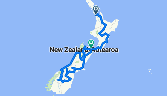
2012 Nieuw Zeeland
A cycling route starting in Mangere, Auckland, New Zealand.
Overview
About this route
- -:--
- Duration
- 3,658.5 km
- Distance
- 5,799 m
- Ascent
- 5,807 m
- Descent
- ---
- Avg. speed
- ---
- Max. altitude

Continue with Bikemap
Use, edit, or download this cycling route
You would like to ride 2012 Nieuw Zeeland or customize it for your own trip? Here is what you can do with this Bikemap route:
Free features
- Save this route as favorite or in collections
- Copy & plan your own version of this route
- Split it into stages to create a multi-day tour
- Sync your route with Garmin or Wahoo
Premium features
Free trial for 3 days, or one-time payment. More about Bikemap Premium.
- Navigate this route on iOS & Android
- Export a GPX / KML file of this route
- Create your custom printout (try it for free)
- Download this route for offline navigation
Discover more Premium features.
Get Bikemap PremiumFrom our community
Other popular routes starting in Mangere
 20km Mangere Bridge to Airport loop
- Distance
- 19.7 km
- Ascent
- 76 m
- Descent
- 79 m
- Location
- Mangere, Auckland, New Zealand
 NZ 2015
- Distance
- 5,735.7 km
- Ascent
- 4,197 m
- Descent
- 4,188 m
- Location
- Mangere, Auckland, New Zealand
 #FORTBIKE🚴🔫
- Distance
- 21.5 km
- Ascent
- 150 m
- Descent
- 151 m
- Location
- Mangere, Auckland, New Zealand
 New Zealand P6 Maranga Option
- Distance
- 1,038.3 km
- Ascent
- 2,668 m
- Descent
- 2,668 m
- Location
- Mangere, Auckland, New Zealand
 第二天的行程:奧克蘭-基督城-福斯冰河小鎮
- Distance
- 1,208.4 km
- Ascent
- 3,890 m
- Descent
- 3,750 m
- Location
- Mangere, Auckland, New Zealand
 🚴💨#BikeLike
- Distance
- 14 km
- Ascent
- 146 m
- Descent
- 157 m
- Location
- Mangere, Auckland, New Zealand
 2012 Nieuw Zeeland
- Distance
- 3,658.5 km
- Ascent
- 5,799 m
- Descent
- 5,807 m
- Location
- Mangere, Auckland, New Zealand
 New Zealand 2013
- Distance
- 4,595.7 km
- Ascent
- 91,417 m
- Descent
- 91,416 m
- Location
- Mangere, Auckland, New Zealand
Open it in the app