

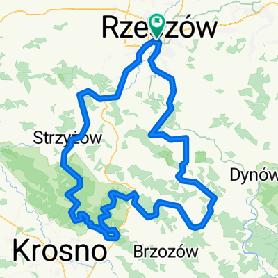
Bożnicza - Staroniwa - Niechobrz - Mogielnica - Boguchwała - Rzeszów
A cycling route starting in Rzeszów, Subcarpathian Voivodeship, Poland.
Overview
About this route
Ride through the streets:
Start from Boznicza via 8-go Marca, the bike path along the Wisłok River, through the new tunnel under the Carpathian Bridge, Emilia Plater, Poznańska, Zawiszy Czarnego, Boya Żeleńskiego, Magazynowa, Staroniwska, Kresowa, paths to Niechobrz and then to Mogielnica, then in Boguchwała via Polna Street, Partyzantów, Boczną - Techniczną, Cichą, in Rzeszów Zwięczycka, Brzegowa, Jarowa, along the Wisłok Reservoir, Olszynki, Sputka Ligenzy, Targowa.
- -:--
- Duration
- 33.1 km
- Distance
- 195 m
- Ascent
- 198 m
- Descent
- ---
- Avg. speed
- ---
- Max. altitude

Route quality
Waytypes & surfaces along the route
Waytypes
Quiet road
11.6 km
(35 %)
Road
7.3 km
(22 %)
Surfaces
Paved
23.8 km
(72 %)
Unpaved
1 km
(3 %)
Asphalt
23.5 km
(71 %)
Gravel
0.7 km
(2 %)
Route highlights
Points of interest along the route
Point of interest after 12.2 km
fotki
Continue with Bikemap
Use, edit, or download this cycling route
You would like to ride Bożnicza - Staroniwa - Niechobrz - Mogielnica - Boguchwała - Rzeszów or customize it for your own trip? Here is what you can do with this Bikemap route:
Free features
- Save this route as favorite or in collections
- Copy & plan your own version of this route
- Sync your route with Garmin or Wahoo
Premium features
Free trial for 3 days, or one-time payment. More about Bikemap Premium.
- Navigate this route on iOS & Android
- Export a GPX / KML file of this route
- Create your custom printout (try it for free)
- Download this route for offline navigation
Discover more Premium features.
Get Bikemap PremiumFrom our community
Other popular routes starting in Rzeszów
 Podjazd na Łany
- Distance
- 15.4 km
- Ascent
- 236 m
- Descent
- 233 m
- Location
- Rzeszów, Subcarpathian Voivodeship, Poland
 Niedzielna przejażdżka z rodziną i znajomymi
- Distance
- 59.1 km
- Ascent
- 120 m
- Descent
- 125 m
- Location
- Rzeszów, Subcarpathian Voivodeship, Poland
 Roch - Chmielnik - Magdalenka - 42 Km
- Distance
- 42.4 km
- Ascent
- 603 m
- Descent
- 601 m
- Location
- Rzeszów, Subcarpathian Voivodeship, Poland
 Kopce Jasienickie - szkic
- Distance
- 150.4 km
- Ascent
- 1,355 m
- Descent
- 1,358 m
- Location
- Rzeszów, Subcarpathian Voivodeship, Poland
 Rzeszów Hermanowa Rzeszów
- Distance
- 34 km
- Ascent
- 238 m
- Descent
- 238 m
- Location
- Rzeszów, Subcarpathian Voivodeship, Poland
 Rzeszów - Albigowa - Rzeszów
- Distance
- 63.2 km
- Ascent
- 417 m
- Descent
- 417 m
- Location
- Rzeszów, Subcarpathian Voivodeship, Poland
 Rzeszów - Roch - Magdalenka - Zalesie - 26 Km
- Distance
- 26 km
- Ascent
- 295 m
- Descent
- 295 m
- Location
- Rzeszów, Subcarpathian Voivodeship, Poland
 20+ trasa
- Distance
- 22.1 km
- Ascent
- 68 m
- Descent
- 69 m
- Location
- Rzeszów, Subcarpathian Voivodeship, Poland
Open it in the app