

ABR Amtsbotenritt 2012
A cycling route starting in Haßfurt, Bavaria, Germany.
Overview
About this route
ABR Amtsbotenritt 07.07.2012 -Half stage route profile-
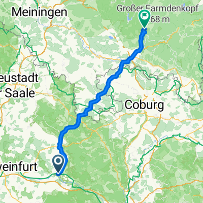
Start: 8:00 AM at the Marketplace
- Refreshment station: Altenstein
- Refreshment station: Krumbach
Lunch break and turning point: Beer garden at the Museum 'Alte Schäferei' Ahorn
Finish: Königsberg, sports grounds TV 1862
Culinary: after noon Grilled sausages Drinks Coffee and cake
Highlight from 6 PM: Franconian lamb on a spit! Draft beer.
- -:--
- Duration
- 43.6 km
- Distance
- 738 m
- Ascent
- 676 m
- Descent
- ---
- Avg. speed
- ---
- Max. altitude

Route quality
Waytypes & surfaces along the route
Waytypes
Track
31.9 km
(73 %)
Quiet road
5.2 km
(12 %)
Surfaces
Paved
11.8 km
(27 %)
Unpaved
25.8 km
(59 %)
Gravel
15.3 km
(35 %)
Ground
8.3 km
(19 %)
Route highlights
Points of interest along the route
Point of interest after 0 km
Start: Marktplatz, 8:00 Uhr. Startlisten ab 7:00 Uhr Ziel: Sportgelände des TV Königsberg; vom Marktplatz ca. 800 m entfernt, Richtung Unfinden/Hofheim
Point of interest after 0 km
Sportgelände TV Königsberg Spiessbraten, Bratwürste, Fassbier; Kaffee und Kuchen!
Point of interest after 20.8 km
Verpflegungsstation Altenstein
Point of interest after 23.5 km
Hier links der Markierung folgen! Aus technischen Gründen ist die Änderung bei bikemap.de nicht möglich.
Point of interest after 23.7 km
tatsächliche Route
Point of interest after 24.3 km
tatsächliche Route
Point of interest after 24.5 km
Ab hier weiter auf der "blauen" Route.
Point of interest after 35.1 km
Verpflegungsstation Krumbach
Point of interest after 38.2 km
Hier scharf links abbiegen!
Point of interest after 43.6 km
Wendepunkt, Verpflegung, Gasthaus
Continue with Bikemap
Use, edit, or download this cycling route
You would like to ride ABR Amtsbotenritt 2012 or customize it for your own trip? Here is what you can do with this Bikemap route:
Free features
- Save this route as favorite or in collections
- Copy & plan your own version of this route
- Sync your route with Garmin or Wahoo
Premium features
Free trial for 3 days, or one-time payment. More about Bikemap Premium.
- Navigate this route on iOS & Android
- Export a GPX / KML file of this route
- Create your custom printout (try it for free)
- Download this route for offline navigation
Discover more Premium features.
Get Bikemap PremiumFrom our community
Other popular routes starting in Haßfurt
 Durch das Tal der klappernden Wassermühlen
- Distance
- 39.9 km
- Ascent
- 0 m
- Descent
- 0 m
- Location
- Haßfurt, Bavaria, Germany
 Coronarunde 2
- Distance
- 13.9 km
- Ascent
- 266 m
- Descent
- 264 m
- Location
- Haßfurt, Bavaria, Germany
 20130628 wasmuthshausen
- Distance
- 35.5 km
- Ascent
- 462 m
- Descent
- 477 m
- Location
- Haßfurt, Bavaria, Germany
 Am Ziegelbrunn, Haßfurt nach Am Badehaus, Masserberg
- Distance
- 80.9 km
- Ascent
- 1,326 m
- Descent
- 757 m
- Location
- Haßfurt, Bavaria, Germany
 Bergrheinfeld - Wurzburg
- Distance
- 111.1 km
- Ascent
- 386 m
- Descent
- 443 m
- Location
- Haßfurt, Bavaria, Germany
 Hassfurt - Volkach
- Distance
- 52.6 km
- Ascent
- 50 m
- Descent
- 74 m
- Location
- Haßfurt, Bavaria, Germany
 2015_Berlin - Büttikon_009
- Distance
- 106.6 km
- Ascent
- 192 m
- Descent
- 111 m
- Location
- Haßfurt, Bavaria, Germany
 Lindenhainstraße, Haßfurt nach Bamberger Straße, Lichtenfels
- Distance
- 89.7 km
- Ascent
- 2,568 m
- Descent
- 2,514 m
- Location
- Haßfurt, Bavaria, Germany
Open it in the app