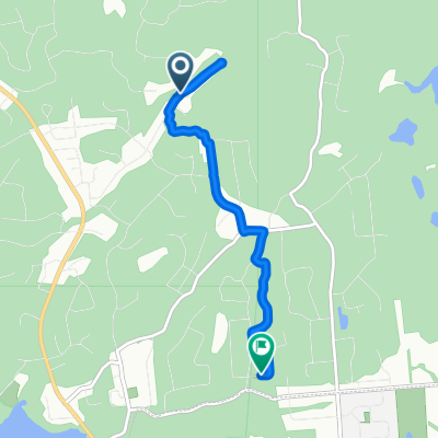
Corridor Rapibus, Gatineau à 79 Rue du Canard, Gatineau
A cycling route starting in Gatineau, Quebec, Canada.
Overview
About this route
- 2 h 19 min
- Duration
- 27.3 km
- Distance
- 243 m
- Ascent
- 150 m
- Descent
- 11.8 km/h
- Avg. speed
- 142 m
- Avg. speed
Continue with Bikemap
Use, edit, or download this cycling route
You would like to ride Corridor Rapibus, Gatineau à 79 Rue du Canard, Gatineau or customize it for your own trip? Here is what you can do with this Bikemap route:
Free features
- Save this route as favorite or in collections
- Copy & plan your own version of this route
- Sync your route with Garmin or Wahoo
Premium features
Free trial for 3 days, or one-time payment. More about Bikemap Premium.
- Navigate this route on iOS & Android
- Export a GPX / KML file of this route
- Create your custom printout (try it for free)
- Download this route for offline navigation
Discover more Premium features.
Get Bikemap PremiumFrom our community
Other popular routes starting in Gatineau
- Day 2 (Kichi Zibi Mikan/George-Étienne-Cartier/Route Verte)
- Distance
- 100.5 km
- Ascent
- 535 m
- Descent
- 537 m
- Location
- Gatineau, Quebec, Canada
- Day 1(2 Rivières-Parc Gatineau)
- Distance
- 61.5 km
- Ascent
- 408 m
- Descent
- 407 m
- Location
- Gatineau, Quebec, Canada
- blackburn convent glen loop
- Distance
- 19.8 km
- Ascent
- 41 m
- Descent
- 43 m
- Location
- Gatineau, Quebec, Canada
- home to Champlain lookout in Gatineau park
- Distance
- 28.5 km
- Ascent
- 441 m
- Descent
- 145 m
- Location
- Gatineau, Quebec, Canada
- route pour demain
- Distance
- 58.5 km
- Ascent
- 97 m
- Descent
- 97 m
- Location
- Gatineau, Quebec, Canada
- Lac Leamy-Aylmer
- Distance
- 47.1 km
- Ascent
- 213 m
- Descent
- 215 m
- Location
- Gatineau, Quebec, Canada
- Gat-Edelw-Wkfld
- Distance
- 56.5 km
- Ascent
- 350 m
- Descent
- 350 m
- Location
- Gatineau, Quebec, Canada
- 6* — Advanced Trail
- Distance
- 6.7 km
- Ascent
- 11 m
- Descent
- 10 m
- Location
- Gatineau, Quebec, Canada
Open it in the app