

Männlichen CLONED FROM ROUTE 332913
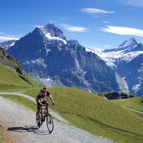
A cycling route starting in Grindelwald, Canton of Bern, Switzerland.
Overview
About this route
schön steil,
zwei weideroste, bz. Elektroschranken (jeweils als Kuhzaun) stören allerhöchtens bei der anschließenden Abfahrt, da oben Sackgasse für Rennveloreifen ist
Die letzten 100 Höhenmeter sind nur ewas für Puristen, die schnell mal etwas Luft rauslassen, um dann auf Schotter weiter zu fahren und dann doch noch die letzten 20 Meter mit dem Rad auf der Schulter hochzugehen.
- -:--
- Duration
- 14.8 km
- Distance
- 1,379 m
- Ascent
- 6 m
- Descent
- ---
- Avg. speed
- ---
- Max. altitude

Route quality
Waytypes & surfaces along the route
Waytypes
Quiet road
14 km
(95 %)
Track
0.7 km
(5 %)
Surfaces
Paved
13.9 km
(94 %)
Unpaved
0.7 km
(5 %)
Asphalt
13.7 km
(93 %)
Gravel
0.7 km
(5 %)
Continue with Bikemap
Use, edit, or download this cycling route
You would like to ride Männlichen CLONED FROM ROUTE 332913 or customize it for your own trip? Here is what you can do with this Bikemap route:
Free features
- Save this route as favorite or in collections
- Copy & plan your own version of this route
- Sync your route with Garmin or Wahoo
Premium features
Free trial for 3 days, or one-time payment. More about Bikemap Premium.
- Navigate this route on iOS & Android
- Export a GPX / KML file of this route
- Create your custom printout (try it for free)
- Download this route for offline navigation
Discover more Premium features.
Get Bikemap PremiumFrom our community
Other popular routes starting in Grindelwald
 1. Tag Grindelwald - Andermatt
- Distance
- 90.7 km
- Ascent
- 3,100 m
- Descent
- 2,700 m
- Location
- Grindelwald, Canton of Bern, Switzerland
 Bachalpsee via Grosse Scheidegg and First
- Distance
- 33.2 km
- Ascent
- 1,308 m
- Descent
- 1,305 m
- Location
- Grindelwald, Canton of Bern, Switzerland
 GWald
GWald- Distance
- 38.6 km
- Ascent
- 1,554 m
- Descent
- 1,559 m
- Location
- Grindelwald, Canton of Bern, Switzerland
 Grindelwald Bachalpsee
- Distance
- 14.2 km
- Ascent
- 184 m
- Descent
- 1,309 m
- Location
- Grindelwald, Canton of Bern, Switzerland
 Grindelwald,Interlaken,Grosse-Scheidegg
- Distance
- 86 km
- Ascent
- 1,902 m
- Descent
- 1,910 m
- Location
- Grindelwald, Canton of Bern, Switzerland
 Grindelwald to Mannlichen
- Distance
- 13.6 km
- Ascent
- 1,321 m
- Descent
- 0 m
- Location
- Grindelwald, Canton of Bern, Switzerland
 Kleine Scheidegg
- Distance
- 41.9 km
- Ascent
- 1,656 m
- Descent
- 1,776 m
- Location
- Grindelwald, Canton of Bern, Switzerland
 Grindelwald to Thun
- Distance
- 47.1 km
- Ascent
- 200 m
- Descent
- 684 m
- Location
- Grindelwald, Canton of Bern, Switzerland
Open it in the app