

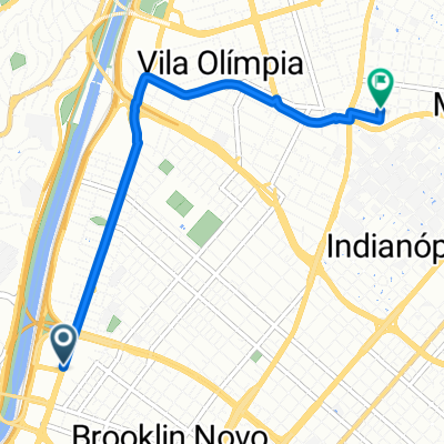
Avenida Giovanni Gronchi até Rua. Cancioneiro Popular
A cycling route starting in Taboão da Serra, São Paulo, Brazil.
Overview
About this route
Route with little traffic in the Morumbi area, be careful when accessing the Morumbi bridge.
- -:--
- Duration
- 4.9 km
- Distance
- 86 m
- Ascent
- 147 m
- Descent
- ---
- Avg. speed
- ---
- Max. altitude
Route quality
Waytypes & surfaces along the route
Waytypes
Quiet road
2.5 km
(51 %)
Undefined
2.4 km
(49 %)
Surfaces
Paved
2.6 km
(53 %)
Asphalt
1.8 km
(36 %)
Paved (undefined)
0.8 km
(17 %)
Undefined
2.3 km
(47 %)
Route highlights
Points of interest along the route
Point of interest after 3.2 km
Deve-se ter cuidado o acesso em si é fácil em frente começa uma curva permaneça a direita.
Point of interest after 3.5 km
Sinalize sua entrada e cuidado com os carros que estão realizando o acesso.
Point of interest after 3.6 km
Carros mudando de faixa para acessar a marginal, sinalize sua intenção de seguir em frente, uma mão com a palma virada sempre ajuda.
Point of interest after 3.7 km
Carros mudando de faixa, você continuará em frente e não esqueça siga sempre sorrindo :)
Continue with Bikemap
Use, edit, or download this cycling route
You would like to ride Avenida Giovanni Gronchi até Rua. Cancioneiro Popular or customize it for your own trip? Here is what you can do with this Bikemap route:
Free features
- Save this route as favorite or in collections
- Copy & plan your own version of this route
- Sync your route with Garmin or Wahoo
Premium features
Free trial for 3 days, or one-time payment. More about Bikemap Premium.
- Navigate this route on iOS & Android
- Export a GPX / KML file of this route
- Create your custom printout (try it for free)
- Download this route for offline navigation
Discover more Premium features.
Get Bikemap PremiumFrom our community
Other popular routes starting in Taboão da Serra
 De Rua Carlos Magalhães a Rua Carlos Magalhães
- Distance
- 48.8 km
- Ascent
- 477 m
- Descent
- 470 m
- Location
- Taboão da Serra, São Paulo, Brazil
 De Rua Carlos Magalhães a Rua Carlos Magalhães
- Distance
- 25.7 km
- Ascent
- 120 m
- Descent
- 109 m
- Location
- Taboão da Serra, São Paulo, Brazil
 Rua : próspero Cesarino paoliello
- Distance
- 8.2 km
- Ascent
- 110 m
- Descent
- 93 m
- Location
- Taboão da Serra, São Paulo, Brazil
 Route to Barbearia Nova
- Distance
- 5.1 km
- Ascent
- 34 m
- Descent
- 17 m
- Location
- Taboão da Serra, São Paulo, Brazil
 De Rua Carlos Magalhães a Avenida Eliseu de Almeida
- Distance
- 19 km
- Ascent
- 172 m
- Descent
- 241 m
- Location
- Taboão da Serra, São Paulo, Brazil
 Rota de quinta rápida com subidas
- Distance
- 44.8 km
- Ascent
- 256 m
- Descent
- 257 m
- Location
- Taboão da Serra, São Paulo, Brazil
 De Rodovia Régis Bittencourt a Avenida Paulista
- Distance
- 25.3 km
- Ascent
- 551 m
- Descent
- 460 m
- Location
- Taboão da Serra, São Paulo, Brazil
![BikeMap[comute]](https://media.bikemap.net/routes/17552678/staticmaps/in_be1791f0-97cd-4aa6-ace7-effad91838c9_400x400_bikemap-2021-3D-static.png) BikeMap[comute]
BikeMap[comute]- Distance
- 4.4 km
- Ascent
- 33 m
- Descent
- 92 m
- Location
- Taboão da Serra, São Paulo, Brazil
Open it in the app