

Route to 6A Marine Walk, Sunderland, SR6 0PP
A cycling route starting in Sunderland, England, United Kingdom.
Overview
About this route
Saturday Brick Session - RUN. Put your bike away, change your shoes, and get busy running! A 1.7km loop taking in the Roker Promenade.
- 7 min
- Duration
- 1.7 km
- Distance
- 16 m
- Ascent
- 16 m
- Descent
- 15.7 km/h
- Avg. speed
- 17 m
- Max. altitude
Route quality
Waytypes & surfaces along the route
Waytypes
Access road
1.1 km
(64 %)
Cycleway
0.5 km
(29 %)
Continue with Bikemap
Use, edit, or download this cycling route
You would like to ride Route to 6A Marine Walk, Sunderland, SR6 0PP or customize it for your own trip? Here is what you can do with this Bikemap route:
Free features
- Save this route as favorite or in collections
- Copy & plan your own version of this route
- Sync your route with Garmin or Wahoo
Premium features
Free trial for 3 days, or one-time payment. More about Bikemap Premium.
- Navigate this route on iOS & Android
- Export a GPX / KML file of this route
- Create your custom printout (try it for free)
- Download this route for offline navigation
Discover more Premium features.
Get Bikemap PremiumFrom our community
Other popular routes starting in Sunderland
 Route to A183, Sunderland, SR6
- Distance
- 7.1 km
- Ascent
- 40 m
- Descent
- 43 m
- Location
- Sunderland, England, United Kingdom
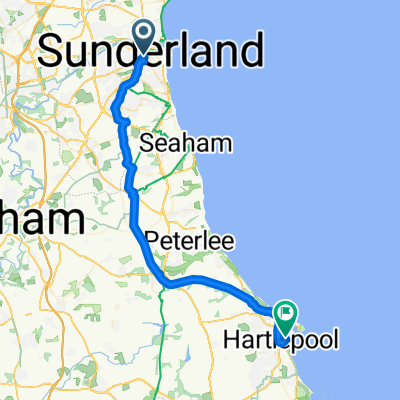 DD..Sunderland to Hartlepool
- Distance
- 38.1 km
- Ascent
- 238 m
- Descent
- 272 m
- Location
- Sunderland, England, United Kingdom
 Route to 6A Marine Walk, Sunderland, SR6 0PP
- Distance
- 1.7 km
- Ascent
- 16 m
- Descent
- 16 m
- Location
- Sunderland, England, United Kingdom
 C2C von Newcastel nach Whitehaven
- Distance
- 220.8 km
- Ascent
- 1,647 m
- Descent
- 1,656 m
- Location
- Sunderland, England, United Kingdom
 Home to beamish
- Distance
- 25.4 km
- Ascent
- 264 m
- Descent
- 141 m
- Location
- Sunderland, England, United Kingdom
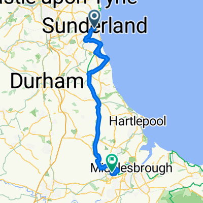 D5 Sunderland to Stockton-on-Tees
- Distance
- 63.9 km
- Ascent
- 411 m
- Descent
- 431 m
- Location
- Sunderland, England, United Kingdom
 Torquay Road 56 to Taunton Square 26
- Distance
- 46.7 km
- Ascent
- 1,107 m
- Descent
- 1,085 m
- Location
- Sunderland, England, United Kingdom
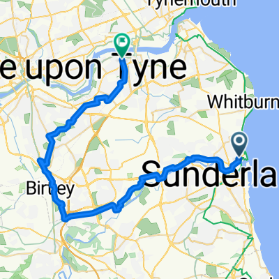 Givens Street, Sunderland to Western Road, Jarrow
- Distance
- 35.8 km
- Ascent
- 318 m
- Descent
- 318 m
- Location
- Sunderland, England, United Kingdom
Open it in the app