

Bangar Puni Bukok Rataie Loop
A cycling route starting in Bangar, Temburong, Brunei.
Overview
About this route
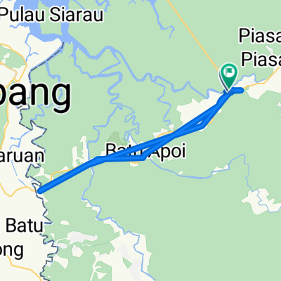
Temburong has two loops, this includes has both. The course starts and finishes close to the ferry terminal. The road is usually good though there are big potholes, especially on the highway at the beginning. The south and north legs follow rivers. There are four short steep hills, some with speed humps at the bottom. The last loop is through the town of Bangar around Kampong Mennengah.
- -:--
- Duration
- 27.4 km
- Distance
- 303 m
- Ascent
- 301 m
- Descent
- ---
- Avg. speed
- ---
- Max. altitude

Route quality
Waytypes & surfaces along the route
Waytypes
Road
20.6 km
(75 %)
Cycleway
3.8 km
(14 %)
Surfaces
Paved
5.5 km
(20 %)
Asphalt
5.5 km
(20 %)
Undefined
21.9 km
(80 %)
Continue with Bikemap
Use, edit, or download this cycling route
You would like to ride Bangar Puni Bukok Rataie Loop or customize it for your own trip? Here is what you can do with this Bikemap route:
Free features
- Save this route as favorite or in collections
- Copy & plan your own version of this route
- Sync your route with Garmin or Wahoo
Premium features
Free trial for 3 days, or one-time payment. More about Bikemap Premium.
- Navigate this route on iOS & Android
- Export a GPX / KML file of this route
- Create your custom printout (try it for free)
- Download this route for offline navigation
Discover more Premium features.
Get Bikemap PremiumFrom our community
Other popular routes starting in Bangar
 Brunei, Bangar to Brunei, Bangar
- Distance
- 2 km
- Ascent
- 12 m
- Descent
- 12 m
- Location
- Bangar, Temburong, Brunei
 Bangar back river cruise
- Distance
- 29.1 km
- Ascent
- 69 m
- Descent
- 72 m
- Location
- Bangar, Temburong, Brunei
 Temburong border to border
- Distance
- 26.9 km
- Ascent
- 292 m
- Descent
- 271 m
- Location
- Bangar, Temburong, Brunei
 Bukit Patoi extension walk
- Distance
- 1.1 km
- Ascent
- 88 m
- Descent
- 28 m
- Location
- Bangar, Temburong, Brunei
 Labu logging track
- Distance
- 13.9 km
- Ascent
- 455 m
- Descent
- 452 m
- Location
- Bangar, Temburong, Brunei
 Restful route
- Distance
- 40.4 km
- Ascent
- 31 m
- Descent
- 84 m
- Location
- Bangar, Temburong, Brunei
 Afternoon Ride
- Distance
- 15 km
- Ascent
- 157 m
- Descent
- 133 m
- Location
- Bangar, Temburong, Brunei
 Bangar Puni Bukok Rataie Loop
- Distance
- 27.4 km
- Ascent
- 303 m
- Descent
- 301 m
- Location
- Bangar, Temburong, Brunei
Open it in the app