Bangar, bike and Bukit Patoi
A cycling route starting in Bangar, Temburong District, Brunei.
Overview
About this route
This a combined cycle and walk, from Bangar to Bukit Patoi. The road is an excellent highway, mostly with a wide shoulder, and the 300m climb up Bukit Patoi follows a very well used trail. At the foot of the climb are buildings, including toilets and water. Make sure you drink often.
It is best done early in the morning to avoid the heat. Even so, you will sweat lots. The ride and the walk both take just over half an hour, so give yourself three hours to look around and complete it.
A day pack with a pair of grippy boots and a couple of water bottles is a good idea. The biggest hazard is the slippery (painted!) concrete steps at the beginning of the climb. Keep a hand on the rail on the way down, as the rain and moss make it worse.
- -:--
- Duration
- 16.1 km
- Distance
- 388 m
- Ascent
- 109 m
- Descent
- ---
- Avg. speed
- ---
- Avg. speed
Continue with Bikemap
Use, edit, or download this cycling route
You would like to ride Bangar, bike and Bukit Patoi or customize it for your own trip? Here is what you can do with this Bikemap route:
Free features
- Save this route as favorite or in collections
- Copy & plan your own version of this route
- Sync your route with Garmin or Wahoo
Premium features
Free trial for 3 days, or one-time payment. More about Bikemap Premium.
- Navigate this route on iOS & Android
- Export a GPX / KML file of this route
- Create your custom printout (try it for free)
- Download this route for offline navigation
Discover more Premium features.
Get Bikemap PremiumFrom our community
Other popular routes starting in Bangar
- app test
- Distance
- 1.1 km
- Ascent
- 194 m
- Descent
- 190 m
- Location
- Bangar, Temburong District, Brunei
- Afternoon Ride
- Distance
- 15 km
- Ascent
- 157 m
- Descent
- 133 m
- Location
- Bangar, Temburong District, Brunei
- Labu logging track
- Distance
- 13.9 km
- Ascent
- 455 m
- Descent
- 452 m
- Location
- Bangar, Temburong District, Brunei
- Temburong border to border
- Distance
- 26.9 km
- Ascent
- 292 m
- Descent
- 271 m
- Location
- Bangar, Temburong District, Brunei
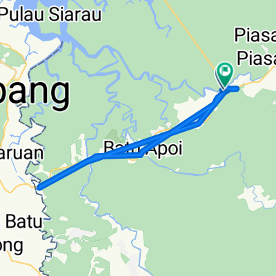
- Bangar back river cruise
- Distance
- 29.1 km
- Ascent
- 69 m
- Descent
- 72 m
- Location
- Bangar, Temburong District, Brunei
- Bangar, bike and Bukit Patoi
- Distance
- 16.1 km
- Ascent
- 388 m
- Descent
- 109 m
- Location
- Bangar, Temburong District, Brunei
- Temada-Sibut track
- Distance
- 6.8 km
- Ascent
- 108 m
- Descent
- 117 m
- Location
- Bangar, Temburong District, Brunei
- Bukit Patoi extension walk
- Distance
- 1.1 km
- Ascent
- 88 m
- Descent
- 28 m
- Location
- Bangar, Temburong District, Brunei
Open it in the app