

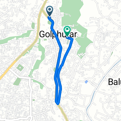
Shree Krishna Dai Route
A cycling route starting in Kathmandu, Central Region, Nepal.
Overview
About this route
- 46 min
- Duration
- 11.9 km
- Distance
- 73 m
- Ascent
- 98 m
- Descent
- 15.7 km/h
- Avg. speed
- 1,354 m
- Max. altitude

Route quality
Waytypes & surfaces along the route
Waytypes
Quiet road
3.7 km
(31 %)
Cycleway
0.8 km
(7 %)
Surfaces
Paved
5.7 km
(48 %)
Unpaved
0.4 km
(3 %)
Asphalt
4.5 km
(38 %)
Paved (undefined)
1.2 km
(10 %)
Continue with Bikemap
Use, edit, or download this cycling route
You would like to ride Shree Krishna Dai Route or customize it for your own trip? Here is what you can do with this Bikemap route:
Free features
- Save this route as favorite or in collections
- Copy & plan your own version of this route
- Sync your route with Garmin or Wahoo
Premium features
Free trial for 3 days, or one-time payment. More about Bikemap Premium.
- Navigate this route on iOS & Android
- Export a GPX / KML file of this route
- Create your custom printout (try it for free)
- Download this route for offline navigation
Discover more Premium features.
Get Bikemap PremiumFrom our community
Other popular routes starting in Kathmandu
 Unnamed Road, Kageshwari Manohara to कागेश्वरी मनोहरा
- Distance
- 33.7 km
- Ascent
- 114 m
- Descent
- 238 m
- Location
- Kathmandu, Central Region, Nepal
 Kathmandu District to Kathmandu District
- Distance
- 2.1 km
- Ascent
- 48 m
- Descent
- 51 m
- Location
- Kathmandu, Central Region, Nepal
 Kunayetwa Marg, Kathmandu to M8X7+M46, Kathmandu
- Distance
- 1.7 km
- Ascent
- 3 m
- Descent
- 5 m
- Location
- Kathmandu, Central Region, Nepal
 Kathmandu District to Kathmandu District
- Distance
- 20.7 km
- Ascent
- 440 m
- Descent
- 445 m
- Location
- Kathmandu, Central Region, Nepal
 veenas-golphutar-mandikatar-kapan-tokha chaneswori-tokha-veenas
- Distance
- 16.1 km
- Ascent
- 271 m
- Descent
- 274 m
- Location
- Kathmandu, Central Region, Nepal
 Moderate route in
- Distance
- 17.3 km
- Ascent
- 220 m
- Descent
- 221 m
- Location
- Kathmandu, Central Region, Nepal
 Shri Ganesh Marg Tinkune, Kathmandu to धलायचा लँ, Lalitpur
- Distance
- 3.1 km
- Ascent
- 46 m
- Descent
- 22 m
- Location
- Kathmandu, Central Region, Nepal
 Kathmandu District to Kathmandu District
- Distance
- 16.6 km
- Ascent
- 302 m
- Descent
- 302 m
- Location
- Kathmandu, Central Region, Nepal
Open it in the app