

Col - Javornik
A cycling route starting in Vipava, Vipava, Slovenia.
Overview
About this route
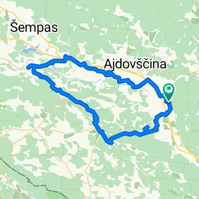
Izlet je iz Velikega kolesarskega vodnika po Sloveniji. Startal sem na Colu, sledi pot v Vodice, na Javornik, Strmec ter nazaj na Col.
- -:--
- Duration
- 22.9 km
- Distance
- 783 m
- Ascent
- 783 m
- Descent
- ---
- Avg. speed
- ---
- Max. altitude

Continue with Bikemap
Use, edit, or download this cycling route
You would like to ride Col - Javornik or customize it for your own trip? Here is what you can do with this Bikemap route:
Free features
- Save this route as favorite or in collections
- Copy & plan your own version of this route
- Sync your route with Garmin or Wahoo
Premium features
Free trial for 3 days, or one-time payment. More about Bikemap Premium.
- Navigate this route on iOS & Android
- Export a GPX / KML file of this route
- Create your custom printout (try it for free)
- Download this route for offline navigation
Discover more Premium features.
Get Bikemap PremiumFrom our community
Other popular routes starting in Vipava
 NA NANOS in dol
- Distance
- 43.1 km
- Ascent
- 877 m
- Descent
- 874 m
- Location
- Vipava, Vipava, Slovenia
 Po Vipavski dolini 2
- Distance
- 58.3 km
- Ascent
- 517 m
- Descent
- 518 m
- Location
- Vipava, Vipava, Slovenia
 Tura po Vipavski dolini
- Distance
- 43.2 km
- Ascent
- 835 m
- Descent
- 834 m
- Location
- Vipava, Vipava, Slovenia
 MTB Ter
- Distance
- 18.8 km
- Ascent
- 448 m
- Descent
- 448 m
- Location
- Vipava, Vipava, Slovenia
 SELO - BRANICA - ŠTJAK
- Distance
- 8.2 km
- Ascent
- 424 m
- Descent
- 426 m
- Location
- Vipava, Vipava, Slovenia
 Vipavska tura
- Distance
- 31.3 km
- Ascent
- 809 m
- Descent
- 809 m
- Location
- Vipava, Vipava, Slovenia
 NANOS
NANOS- Distance
- 47.3 km
- Ascent
- 1,505 m
- Descent
- 1,503 m
- Location
- Vipava, Vipava, Slovenia
 Col - Javornik
- Distance
- 22.9 km
- Ascent
- 783 m
- Descent
- 783 m
- Location
- Vipava, Vipava, Slovenia
Open it in the app