

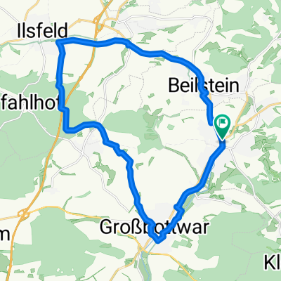
Rute mit anspruchsvoller Steigung und rasanter Abfahrt
A cycling route starting in Oberstenfeld, Baden-Württemberg, Germany.
Overview
About this route
Gut für einen Sonntag im Frühsommer da mann auch im Breitenauer See baden kann. Für weniger ambitionierte Fahrer ist es möglich den Weg vom Ziel an zu fahren da mann so den steilen Anstieg über die Löwensteinerberge auslässt. Für alle anderen gilt im allgemeinen vorsicht beim nutzen der Landstrasse zwischen Prevorst und Löwenstein stark von Motorrädern verwendet wird.
- -:--
- Duration
- 46.2 km
- Distance
- 824 m
- Ascent
- 811 m
- Descent
- ---
- Avg. speed
- 513 m
- Avg. speed
Route quality
Waytypes & surfaces along the route
Waytypes
Busy road
18.3 km
(40 %)
Quiet road
11.9 km
(26 %)
Surfaces
Paved
40.4 km
(87 %)
Unpaved
2.2 km
(5 %)
Asphalt
39 km
(84 %)
Paved (undefined)
1.4 km
(3 %)
Continue with Bikemap
Use, edit, or download this cycling route
You would like to ride Rute mit anspruchsvoller Steigung und rasanter Abfahrt or customize it for your own trip? Here is what you can do with this Bikemap route:
Free features
- Save this route as favorite or in collections
- Copy & plan your own version of this route
- Sync your route with Garmin or Wahoo
Premium features
Free trial for 3 days, or one-time payment. More about Bikemap Premium.
- Navigate this route on iOS & Android
- Export a GPX / KML file of this route
- Create your custom printout (try it for free)
- Download this route for offline navigation
Discover more Premium features.
Get Bikemap PremiumFrom our community
Other popular routes starting in Oberstenfeld
 Bottwartal-Gronau-Neuwirtshaus-Forsthof-Steinheim
- Distance
- 35.9 km
- Ascent
- 268 m
- Descent
- 394 m
- Location
- Oberstenfeld, Baden-Württemberg, Germany
 Oberstenfeld in die Spiegelbergrund
- Distance
- 41.8 km
- Ascent
- 697 m
- Descent
- 696 m
- Location
- Oberstenfeld, Baden-Württemberg, Germany
 Ilsfeld - Wunnenstein - Großbottwar
- Distance
- 20.3 km
- Ascent
- 178 m
- Descent
- 178 m
- Location
- Oberstenfeld, Baden-Württemberg, Germany
 Gronau roundtrip
- Distance
- 51.3 km
- Ascent
- 950 m
- Descent
- 950 m
- Location
- Oberstenfeld, Baden-Württemberg, Germany
 Gronau - xxx - Gronau
- Distance
- 99.3 km
- Ascent
- 1,104 m
- Descent
- 1,103 m
- Location
- Oberstenfeld, Baden-Württemberg, Germany
 Rute mit anspruchsvoller Steigung und rasanter Abfahrt
- Distance
- 46.2 km
- Ascent
- 824 m
- Descent
- 811 m
- Location
- Oberstenfeld, Baden-Württemberg, Germany
 Forsthof
- Distance
- 19.1 km
- Ascent
- 217 m
- Descent
- 221 m
- Location
- Oberstenfeld, Baden-Württemberg, Germany
 Loewensteiner Berge
- Distance
- 61.5 km
- Ascent
- 905 m
- Descent
- 905 m
- Location
- Oberstenfeld, Baden-Württemberg, Germany
Open it in the app