

Overview
About this route
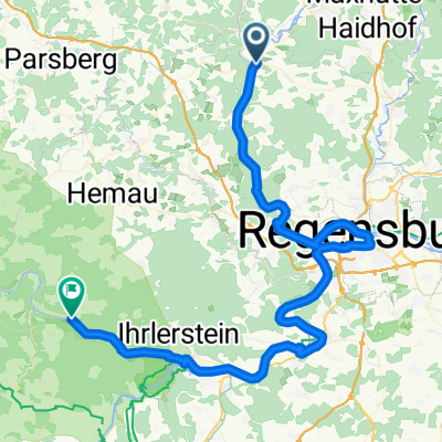
Sixth and final day of the Five Rivers Cycling Tour. From Kallmünz, we head back to Regensburg along the Naab to the parking lot.
- -:--
- Duration
- 33.5 km
- Distance
- 412 m
- Ascent
- 378 m
- Descent
- ---
- Avg. speed
- 436 m
- Max. altitude

Part of
Fünf-Flüsse-Radtour
7 stages
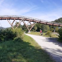
Route photos


Route quality
Waytypes & surfaces along the route
Waytypes
Quiet road
12.7 km
(38 %)
Path
7.7 km
(23 %)
Surfaces
Paved
18.7 km
(56 %)
Unpaved
9.7 km
(29 %)
Asphalt
18.7 km
(56 %)
Gravel
6 km
(18 %)
Continue with Bikemap
Use, edit, or download this cycling route
You would like to ride Kallmünz bis Regensburg or customize it for your own trip? Here is what you can do with this Bikemap route:
Free features
- Save this route as favorite or in collections
- Copy & plan your own version of this route
- Sync your route with Garmin or Wahoo
Premium features
Free trial for 3 days, or one-time payment. More about Bikemap Premium.
- Navigate this route on iOS & Android
- Export a GPX / KML file of this route
- Create your custom printout (try it for free)
- Download this route for offline navigation
Discover more Premium features.
Get Bikemap PremiumFrom our community
Other popular routes starting in Kallmünz
 Kallmünz nach Wörth an der Isar
- Distance
- 96.1 km
- Ascent
- 976 m
- Descent
- 965 m
- Location
- Kallmünz, Bavaria, Germany
 Kallmünz_Schmidmühlen
- Distance
- 17.9 km
- Ascent
- 462 m
- Descent
- 492 m
- Location
- Kallmünz, Bavaria, Germany
 Kallmünz - Regensburg über Pettendorf
- Distance
- 27.1 km
- Ascent
- 243 m
- Descent
- 238 m
- Location
- Kallmünz, Bavaria, Germany
 Rundweg Naab-Donau-Regen-Schwarzach
- Distance
- 188.3 km
- Ascent
- 385 m
- Descent
- 361 m
- Location
- Kallmünz, Bavaria, Germany
 Kallmünz - Waldsassen
- Distance
- 124.5 km
- Ascent
- 487 m
- Descent
- 343 m
- Location
- Kallmünz, Bavaria, Germany
 Naabfahrt Kallmünz-Burglengenfeld
- Distance
- 9.6 km
- Ascent
- 106 m
- Descent
- 100 m
- Location
- Kallmünz, Bavaria, Germany
 Naabtal-Donau bis Weltenburg
- Distance
- 63 km
- Ascent
- 427 m
- Descent
- 405 m
- Location
- Kallmünz, Bavaria, Germany
 PVDA-Tag2
- Distance
- 79.8 km
- Ascent
- 512 m
- Descent
- 513 m
- Location
- Kallmünz, Bavaria, Germany
Open it in the app