

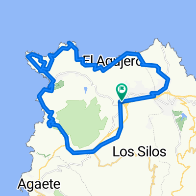
Gáldar-La Atalaya-Sardina-Hoya Pineda-Marmolejo-Gáldar
A cycling route starting in Gáldar, Canary Islands, Spain.
Overview
About this route
A route I put together to get some practice, it goes about 70% on roads and 30% on dirt tracks. I went down to some beaches via somewhat technical paths and there were some sections where you have to walk. Otherwise, very fun and easy, done in 1 hour 40 minutes.
- -:--
- Duration
- 29.8 km
- Distance
- 480 m
- Ascent
- 480 m
- Descent
- ---
- Avg. speed
- ---
- Max. altitude
Route quality
Waytypes & surfaces along the route
Waytypes
Quiet road
18.5 km
(62 %)
Track
6.5 km
(22 %)
Surfaces
Paved
10.7 km
(36 %)
Unpaved
6.2 km
(21 %)
Asphalt
9.8 km
(33 %)
Ground
3.3 km
(11 %)
Continue with Bikemap
Use, edit, or download this cycling route
You would like to ride Gáldar-La Atalaya-Sardina-Hoya Pineda-Marmolejo-Gáldar or customize it for your own trip? Here is what you can do with this Bikemap route:
Free features
- Save this route as favorite or in collections
- Copy & plan your own version of this route
- Sync your route with Garmin or Wahoo
Premium features
Free trial for 3 days, or one-time payment. More about Bikemap Premium.
- Navigate this route on iOS & Android
- Export a GPX / KML file of this route
- Create your custom printout (try it for free)
- Download this route for offline navigation
Discover more Premium features.
Get Bikemap PremiumFrom our community
Other popular routes starting in Gáldar
 North to South Day 2
- Distance
- 114.2 km
- Ascent
- 3,016 m
- Descent
- 3,073 m
- Location
- Gáldar, Canary Islands, Spain
 13.08.15
- Distance
- 51.9 km
- Ascent
- 1,204 m
- Descent
- 1,201 m
- Location
- Gáldar, Canary Islands, Spain
 Municipal Guía
- Distance
- 12.9 km
- Ascent
- 411 m
- Descent
- 258 m
- Location
- Gáldar, Canary Islands, Spain
 Espagne 2 : Gáldar - Las Palmas de Gran Canaria (TTT)
- Distance
- 40.5 km
- Ascent
- 614 m
- Descent
- 554 m
- Location
- Gáldar, Canary Islands, Spain
 Sardina del Norte
- Distance
- 54.7 km
- Ascent
- 705 m
- Descent
- 709 m
- Location
- Gáldar, Canary Islands, Spain
 12-07- Costa Norte por Galdar y Sardina
- Distance
- 32.5 km
- Ascent
- 495 m
- Descent
- 495 m
- Location
- Gáldar, Canary Islands, Spain
 Gáldar-La Atalaya-Sardina-Hoya Pineda-Marmolejo-Gáldar
- Distance
- 29.8 km
- Ascent
- 480 m
- Descent
- 480 m
- Location
- Gáldar, Canary Islands, Spain
 GALDAR-ARTENARA-AGAETE-GALDAR
- Distance
- 77.2 km
- Ascent
- 1,740 m
- Descent
- 1,742 m
- Location
- Gáldar, Canary Islands, Spain
Open it in the app