

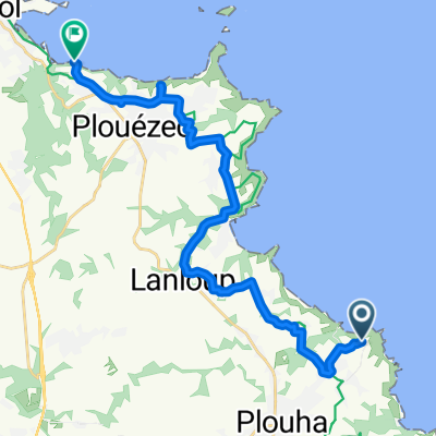
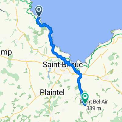
Tag 18: Bretagne 8
A cycling route starting in Plouha, Brittany Region, France.
Overview
About this route
- -:--
- Duration
- 88.1 km
- Distance
- 1,020 m
- Ascent
- 1,090 m
- Descent
- ---
- Avg. speed
- 130 m
- Max. altitude

Route photos


Route quality
Waytypes & surfaces along the route
Waytypes
Quiet road
33.9 km
(38 %)
Road
27.7 km
(31 %)
Surfaces
Paved
46.5 km
(53 %)
Unpaved
7.9 km
(9 %)
Asphalt
44.6 km
(51 %)
Gravel
4 km
(5 %)
Continue with Bikemap
Use, edit, or download this cycling route
You would like to ride Tag 18: Bretagne 8 or customize it for your own trip? Here is what you can do with this Bikemap route:
Free features
- Save this route as favorite or in collections
- Copy & plan your own version of this route
- Split it into stages to create a multi-day tour
- Sync your route with Garmin or Wahoo
Premium features
Free trial for 3 days, or one-time payment. More about Bikemap Premium.
- Navigate this route on iOS & Android
- Export a GPX / KML file of this route
- Create your custom printout (try it for free)
- Download this route for offline navigation
Discover more Premium features.
Get Bikemap PremiumFrom our community
Other popular routes starting in Plouha
 Plouha nach Hent Don Kerarzic, Paimpol
- Distance
- 20.1 km
- Ascent
- 191 m
- Descent
- 264 m
- Location
- Plouha, Brittany Region, France
 1 PLOUHA - MONCONTOUR- 61.7 KM
- Distance
- 61.5 km
- Ascent
- 522 m
- Descent
- 457 m
- Location
- Plouha, Brittany Region, France
 Plohua - Paimpol
- Distance
- 21.6 km
- Ascent
- 174 m
- Descent
- 259 m
- Location
- Plouha, Brittany Region, France
 Plouha - Paimpol
- Distance
- 23.9 km
- Ascent
- 155 m
- Descent
- 229 m
- Location
- Plouha, Brittany Region, France
 Lannion Roads
- Distance
- 63.9 km
- Ascent
- 529 m
- Descent
- 547 m
- Location
- Plouha, Brittany Region, France
 20 - Keroziel nach Carantec
- Distance
- 105.6 km
- Ascent
- 497 m
- Descent
- 584 m
- Location
- Plouha, Brittany Region, France
 De Trévros 36, Plouha à Route de l'Arcouest 21, Ploubazlanec
- Distance
- 29.2 km
- Ascent
- 311 m
- Descent
- 331 m
- Location
- Plouha, Brittany Region, France
 Le Palus, Plouha à 55 Route de Bréhec, Plouha
- Distance
- 19.4 km
- Ascent
- 627 m
- Descent
- 630 m
- Location
- Plouha, Brittany Region, France
Open it in the app