

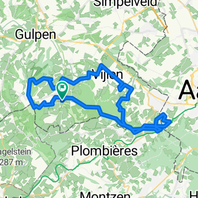
limburg: epen- voerstreek- slenaken
A cycling route starting in Vaals, Limburg, The Netherlands.
Overview
About this route
- -:--
- Duration
- 31.7 km
- Distance
- 465 m
- Ascent
- 465 m
- Descent
- ---
- Avg. speed
- ---
- Max. altitude

Route quality
Waytypes & surfaces along the route
Waytypes
Road
20 km
(63 %)
Quiet road
11.1 km
(35 %)
Cycleway
0.6 km
(2 %)
Surfaces
Paved
25 km
(79 %)
Asphalt
24.4 km
(77 %)
Concrete
0.6 km
(2 %)
Undefined
6.7 km
(21 %)
Route highlights
Points of interest along the route
Point of interest after 4 km
elzeterweg Voet: 107 m Top: 147 m Gemiddelde helling: 2.7% Lengte: 1560 m
Point of interest after 8.1 km
pannisberg Voet: 159 m Top: 256 m Gemiddelde helling: 4.4% Lengte: 2280 m
Point of interest after 15.5 km
smidsberg Voet: 123 m Top: 183 m Gemiddelde helling: 3.0% Lengte: 2250 m
Point of interest after 18 km
Rue de Beusdael (248m) Hoogteverschil : 146m Lengte : 2.3 km Gem. stijging : 6.3%
Point of interest after 23.6 km
schilberg Voet: 146 m Top: 212 m Gemiddelde helling: 6.9% Lengte: 960 m
Point of interest after 28.1 km
loorberg Voet: 139 m Top: 218 m Gemiddelde helling: 4.9% Lengte: 1620 m
Continue with Bikemap
Use, edit, or download this cycling route
You would like to ride limburg: epen- voerstreek- slenaken or customize it for your own trip? Here is what you can do with this Bikemap route:
Free features
- Save this route as favorite or in collections
- Copy & plan your own version of this route
- Sync your route with Garmin or Wahoo
Premium features
Free trial for 3 days, or one-time payment. More about Bikemap Premium.
- Navigate this route on iOS & Android
- Export a GPX / KML file of this route
- Create your custom printout (try it for free)
- Download this route for offline navigation
Discover more Premium features.
Get Bikemap PremiumFrom our community
Other popular routes starting in Vaals
 Bocycle 20120506 Limburg tour
- Distance
- 45.9 km
- Ascent
- 440 m
- Descent
- 441 m
- Location
- Vaals, Limburg, The Netherlands
 rondje Epen
- Distance
- 111.1 km
- Ascent
- 903 m
- Descent
- 903 m
- Location
- Vaals, Limburg, The Netherlands
 START
START- Distance
- 37.2 km
- Ascent
- 492 m
- Descent
- 494 m
- Location
- Vaals, Limburg, The Netherlands
 Camping Rozenhof-Cimetiére Henri Chapelle-Aubel-Camping Rozenhof
- Distance
- 26.8 km
- Ascent
- 474 m
- Descent
- 473 m
- Location
- Vaals, Limburg, The Netherlands
 Rondje Limburgse heuvels
- Distance
- 79.9 km
- Ascent
- 780 m
- Descent
- 779 m
- Location
- Vaals, Limburg, The Netherlands
 Route zu Camping Rozenhof
- Distance
- 28.5 km
- Ascent
- 479 m
- Descent
- 478 m
- Location
- Vaals, Limburg, The Netherlands
 vijlen-monschau dag 1
- Distance
- 64 km
- Ascent
- 564 m
- Descent
- 302 m
- Location
- Vaals, Limburg, The Netherlands
 Limburg 2025b
- Distance
- 50.6 km
- Ascent
- 727 m
- Descent
- 725 m
- Location
- Vaals, Limburg, The Netherlands
Open it in the app