

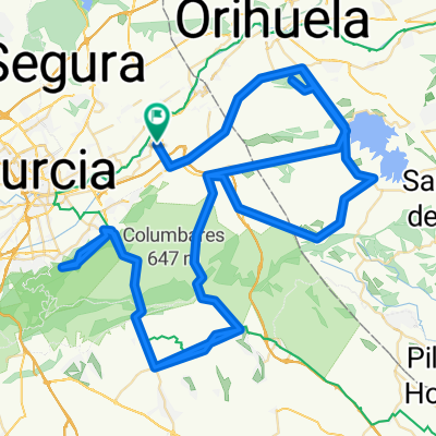
LA PINILLA
A cycling route starting in Beniel, Murcia, Spain.
Overview
About this route
ALQUERIAS, LA MACHACANTA, CALLE MAYOR DE LOS VILLANUEVA, CAMINO DE LOS PINOS, ORILLA DEL REGUERON, CTRA DE ALGEZARES, DESVIO COSTERA SUR, EL PALMAR, SANGONERA LA VERDE, CAÑARICO, HASTA AUTOVIA ALHAMA-CAMPO DE CARTAGENA, CRUZAMOS Y TOMAMOS LADO DERECHO DE AUTOVIA DE MAZARRON LA CUAL CRUZAREMOS EN UN PAR DE VECES DE LADO A LADO, CAMPOSOL, LLEGAREMOS A ROTONDA DONDE SE DIVISA EL CABEZO NEGRO Y GIRAREMOS A LA IZQUIERDA DIRECCION LA PINILLA, LA PINILLA, CUEVAS DEL REYLLO, CORVERA, LOS MARTINEZ DEL PUERTO, ALTO DEL GARRUCAL, EL BOJAL, TORREAGUERA, LOS RAMOS, ALQUERIAS, 140 KLM.
- -:--
- Duration
- 140.1 km
- Distance
- 600 m
- Ascent
- 600 m
- Descent
- ---
- Avg. speed
- ---
- Max. altitude

Route quality
Waytypes & surfaces along the route
Waytypes
Busy road
65 km
(46 %)
Quiet road
46.6 km
(33 %)
Surfaces
Paved
47.5 km
(34 %)
Unpaved
5.1 km
(4 %)
Asphalt
45.5 km
(32 %)
Gravel
3.5 km
(2 %)
Continue with Bikemap
Use, edit, or download this cycling route
You would like to ride LA PINILLA or customize it for your own trip? Here is what you can do with this Bikemap route:
Free features
- Save this route as favorite or in collections
- Copy & plan your own version of this route
- Split it into stages to create a multi-day tour
- Sync your route with Garmin or Wahoo
Premium features
Free trial for 3 days, or one-time payment. More about Bikemap Premium.
- Navigate this route on iOS & Android
- Export a GPX / KML file of this route
- Create your custom printout (try it for free)
- Download this route for offline navigation
Discover more Premium features.
Get Bikemap PremiumFrom our community
Other popular routes starting in Beniel
 TRES EMBALSES
- Distance
- 110.1 km
- Ascent
- 673 m
- Descent
- 677 m
- Location
- Beniel, Murcia, Spain
 ALQUERIAS -MALECÓN 28 MAYO
- Distance
- 19.3 km
- Ascent
- 43 m
- Descent
- 44 m
- Location
- Beniel, Murcia, Spain
 casas blancas1
- Distance
- 70.3 km
- Ascent
- 523 m
- Descent
- 524 m
- Location
- Beniel, Murcia, Spain
 GENOVINOS-GARRUCHAL-CRESTA DEL GALLO-CRESTA-GARRUCHAL-GENOVINOS-ANTENAS DE HURCHILLO
- Distance
- 158.4 km
- Ascent
- 1,217 m
- Descent
- 1,218 m
- Location
- Beniel, Murcia, Spain
 GUARDAMAR, TORREVIEJA, EL PILAR
- Distance
- 113 km
- Ascent
- 446 m
- Descent
- 445 m
- Location
- Beniel, Murcia, Spain
 los tres perdios
- Distance
- 45.7 km
- Ascent
- 626 m
- Descent
- 629 m
- Location
- Beniel, Murcia, Spain
 alquerias, abanilla, macisvenda, el canton, cañada de la leña, fortuna, abanilla, alquerias
- Distance
- 92 km
- Ascent
- 1,183 m
- Descent
- 1,185 m
- Location
- Beniel, Murcia, Spain
 SANTUARIO VIRGEN DEL ORO (ABARAN)
- Distance
- 122.4 km
- Ascent
- 601 m
- Descent
- 601 m
- Location
- Beniel, Murcia, Spain
Open it in the app