

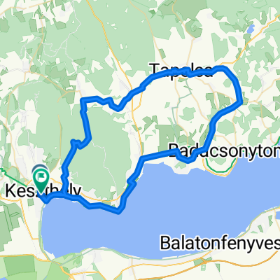
Keszthely - Szigliget
A cycling route starting in Keszthely, Zala County, Hungary.
Overview
About this route
Keszthely - Szigliget bringaúton, nagy északi szélben.
- -:--
- Duration
- 43.7 km
- Distance
- 87 m
- Ascent
- 87 m
- Descent
- ---
- Avg. speed
- ---
- Max. altitude
Route quality
Waytypes & surfaces along the route
Waytypes
Cycleway
29.7 km
(68 %)
Quiet road
7.9 km
(18 %)
Surfaces
Paved
41.8 km
(96 %)
Unpaved
0.7 km
(2 %)
Asphalt
41.6 km
(95 %)
Unpaved (undefined)
0.4 km
(<1 %)
Continue with Bikemap
Use, edit, or download this cycling route
You would like to ride Keszthely - Szigliget or customize it for your own trip? Here is what you can do with this Bikemap route:
Free features
- Save this route as favorite or in collections
- Copy & plan your own version of this route
- Sync your route with Garmin or Wahoo
Premium features
Free trial for 3 days, or one-time payment. More about Bikemap Premium.
- Navigate this route on iOS & Android
- Export a GPX / KML file of this route
- Create your custom printout (try it for free)
- Download this route for offline navigation
Discover more Premium features.
Get Bikemap PremiumFrom our community
Other popular routes starting in Keszthely
 Pipacs utca 55, Keszthely - Pipacs utca 57, Keszthely
- Distance
- 13.7 km
- Ascent
- 58 m
- Descent
- 48 m
- Location
- Keszthely, Zala County, Hungary
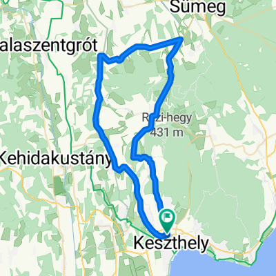
 Keszthely-Szigliget-Tapolca-Keszthely
- Distance
- 72.2 km
- Ascent
- 437 m
- Descent
- 443 m
- Location
- Keszthely, Zala County, Hungary
 KH - Rezi - Sümegprága - Kisgörbö - Karmacs - KH
- Distance
- 54.6 km
- Ascent
- 365 m
- Descent
- 365 m
- Location
- Keszthely, Zala County, Hungary
 Lake Balaton
- Distance
- 71 km
- Ascent
- 358 m
- Descent
- 341 m
- Location
- Keszthely, Zala County, Hungary
 KIS-BALATON kör
- Distance
- 77.9 km
- Ascent
- 370 m
- Descent
- 368 m
- Location
- Keszthely, Zala County, Hungary
 Bakonyerdö túra
- Distance
- 31.1 km
- Ascent
- 292 m
- Descent
- 290 m
- Location
- Keszthely, Zala County, Hungary
 Keszhely - Veszprém
- Distance
- 112.4 km
- Ascent
- 448 m
- Descent
- 284 m
- Location
- Keszthely, Zala County, Hungary
 KH - Rezi - Óhíd - Zalaszentgrót - Sarmelék - KH
- Distance
- 81.2 km
- Ascent
- 382 m
- Descent
- 385 m
- Location
- Keszthely, Zala County, Hungary
Open it in the app