
Nifty 10-50
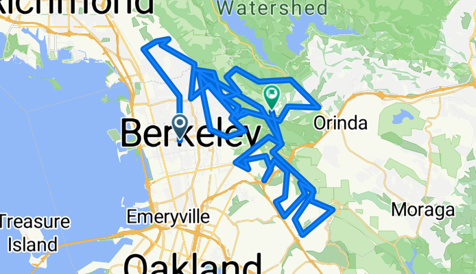
A cycling route starting in Berkeley, California, United States of America.
Overview
About this route
- -:--
- Duration
- 95 km
- Distance
- 2,424 m
- Ascent
- 1,896 m
- Descent
- ---
- Avg. speed
- ---
- Max. altitude
Route quality
Waytypes & surfaces along the route
Waytypes
Road
52.4 km
(55 %)
Quiet road
27.1 km
(29 %)
Surfaces
Paved
61.7 km
(65 %)
Unpaved
1.1 km
(1 %)
Asphalt
44.6 km
(47 %)
Paved (undefined)
16 km
(17 %)
Continue with Bikemap
Use, edit, or download this cycling route
You would like to ride Nifty 10-50 or customize it for your own trip? Here is what you can do with this Bikemap route:
Free features
- Save this route as favorite or in collections
- Copy & plan your own version of this route
- Split it into stages to create a multi-day tour
- Sync your route with Garmin or Wahoo
Premium features
Free trial for 3 days, or one-time payment. More about Bikemap Premium.
- Navigate this route on iOS & Android
- Export a GPX / KML file of this route
- Create your custom printout (try it for free)
- Download this route for offline navigation
Discover more Premium features.
Get Bikemap PremiumFrom our community
Other popular routes starting in Berkeley
 Short Commute
- Distance
- 18.1 km
- Ascent
- 438 m
- Descent
- 439 m
- Location
- Berkeley, California, United States of America
 Bears
Bears- Distance
- 56.6 km
- Ascent
- 926 m
- Descent
- 929 m
- Location
- Berkeley, California, United States of America
 Spruce Wildcat Orinda Toyonal (SWOT)
- Distance
- 30.1 km
- Ascent
- 759 m
- Descent
- 759 m
- Location
- Berkeley, California, United States of America
 work commute
- Distance
- 24.5 km
- Ascent
- 487 m
- Descent
- 475 m
- Location
- Berkeley, California, United States of America
 Tilden Loop
- Distance
- 16.4 km
- Ascent
- 327 m
- Descent
- 324 m
- Location
- Berkeley, California, United States of America
 Cent, Sp, CoCo
- Distance
- 52.9 km
- Ascent
- 1,082 m
- Descent
- 1,082 m
- Location
- Berkeley, California, United States of America
 Castro Valley-Reliz Valley-Deer Hill-Wildcat
- Distance
- 66.3 km
- Ascent
- 954 m
- Descent
- 952 m
- Location
- Berkeley, California, United States of America
 N Oakland - Tunnel Rd - Skyline - Grizzly Pk - Spruce - N Oakland
- Distance
- 29.2 km
- Ascent
- 948 m
- Descent
- 932 m
- Location
- Berkeley, California, United States of America
Open it in the app