

Rolê noturno com Vagnão!
A cycling route starting in Taboão da Serra, São Paulo, Brazil.
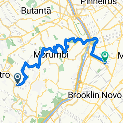
Overview
About this route
Indo, indo, indo, without much destination, until I can hold on
- -:--
- Duration
- 29.8 km
- Distance
- 282 m
- Ascent
- 240 m
- Descent
- ---
- Avg. speed
- ---
- Max. altitude

Route highlights
Points of interest along the route
Point of interest after 10.8 km
Adventure Sports Fair!!! Encontro com Vavá!!!
Point of interest after 16.1 km
Bar do Geraldo SEEEEEEMPREEEEE
Point of interest after 22.3 km
Sesc Pompéia!
Point of interest after 26.8 km
Minhocão de noite tomado de gente!!! lindo!!
Point of interest after 27.5 km
Paradinha na Matilha Cultural
Point of interest after 29.8 km
Metrô Liberdade. Me acovardei.
Continue with Bikemap
Use, edit, or download this cycling route
You would like to ride Rolê noturno com Vagnão! or customize it for your own trip? Here is what you can do with this Bikemap route:
Free features
- Save this route as favorite or in collections
- Copy & plan your own version of this route
- Sync your route with Garmin or Wahoo
Premium features
Free trial for 3 days, or one-time payment. More about Bikemap Premium.
- Navigate this route on iOS & Android
- Export a GPX / KML file of this route
- Create your custom printout (try it for free)
- Download this route for offline navigation
Discover more Premium features.
Get Bikemap PremiumFrom our community
Other popular routes starting in Taboão da Serra
 Rua Camilo Prates 72 - Santo Amaro - SP
- Distance
- 35.6 km
- Ascent
- 852 m
- Descent
- 853 m
- Location
- Taboão da Serra, São Paulo, Brazil
 Rota Ibirapuera Taboão Bikers
- Distance
- 34.5 km
- Ascent
- 131 m
- Descent
- 133 m
- Location
- Taboão da Serra, São Paulo, Brazil
 Portal-Do-Morumbi-Vila-Olimpia-quase-sem-subidas
- Distance
- 13.5 km
- Ascent
- 98 m
- Descent
- 145 m
- Location
- Taboão da Serra, São Paulo, Brazil
 SP-PETAR-RS
- Distance
- 1,665.4 km
- Ascent
- 1,259 m
- Descent
- 2,063 m
- Location
- Taboão da Serra, São Paulo, Brazil
 Rota Marcia Prado - Taboão da Serra à Santos
- Distance
- 105.8 km
- Ascent
- 403 m
- Descent
- 1,169 m
- Location
- Taboão da Serra, São Paulo, Brazil
 Pirajuçara - Represa Cotia.
- Distance
- 56.2 km
- Ascent
- 448 m
- Descent
- 448 m
- Location
- Taboão da Serra, São Paulo, Brazil
 Portal-Do-Morumbi-Vila-Olimpia-sem-passar-pela-Giovanni-Gronchi
- Distance
- 13.8 km
- Ascent
- 184 m
- Descent
- 230 m
- Location
- Taboão da Serra, São Paulo, Brazil
 De Rua João de Sousa Carvalho 7441 a Unnamed Road
- Distance
- 12.3 km
- Ascent
- 129 m
- Descent
- 218 m
- Location
- Taboão da Serra, São Paulo, Brazil
Open it in the app