
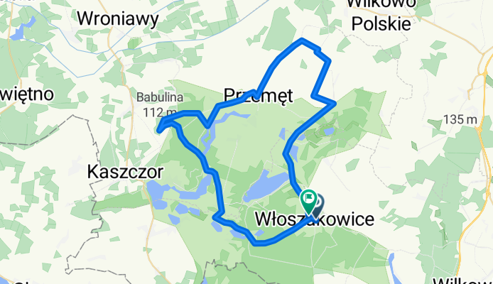
Najwyższa Góra naszego Regionu- Babulinka (112m n.p.m.)
A cycling route starting in Włoszakowice, Greater Poland Voivodeship, Poland.
Overview
About this route
jest to najwyższe wzniesienie w całym powiecie wolsztyńskim. Położona jest około 700m na północ od punktu Lehmanna czyli skrzyżowania drogi łączącej Mochy z Osłonina z drogą łączącą Kaszczor z Perkowem
- -:--
- Duration
- 50.1 km
- Distance
- 163 m
- Ascent
- 168 m
- Descent
- ---
- Avg. speed
- ---
- Max. altitude

Continue with Bikemap
Use, edit, or download this cycling route
You would like to ride Najwyższa Góra naszego Regionu- Babulinka (112m n.p.m.) or customize it for your own trip? Here is what you can do with this Bikemap route:
Free features
- Save this route as favorite or in collections
- Copy & plan your own version of this route
- Sync your route with Garmin or Wahoo
Premium features
Free trial for 3 days, or one-time payment. More about Bikemap Premium.
- Navigate this route on iOS & Android
- Export a GPX / KML file of this route
- Create your custom printout (try it for free)
- Download this route for offline navigation
Discover more Premium features.
Get Bikemap PremiumFrom our community
Other popular routes starting in Włoszakowice
 boszkowo
- Distance
- 35.6 km
- Ascent
- 126 m
- Descent
- 126 m
- Location
- Włoszakowice, Greater Poland Voivodeship, Poland
 Śladami Napoleona- Kanapa Napoleona Charbielin
- Distance
- 16 km
- Ascent
- 59 m
- Descent
- 64 m
- Location
- Włoszakowice, Greater Poland Voivodeship, Poland
 Najwyższa Góra naszego Regionu- Babulinka (112m n.p.m.)
- Distance
- 50.1 km
- Ascent
- 163 m
- Descent
- 168 m
- Location
- Włoszakowice, Greater Poland Voivodeship, Poland
 Rowerowy Szlak Konwaliowy
- Distance
- 44.1 km
- Ascent
- 221 m
- Descent
- 222 m
- Location
- Włoszakowice, Greater Poland Voivodeship, Poland
 Szlak rowerowy "Miejsca z pierwszego i drugiegi sezonu ŚPR"
- Distance
- 28.2 km
- Ascent
- 117 m
- Descent
- 115 m
- Location
- Włoszakowice, Greater Poland Voivodeship, Poland
 Starkowska 1, Włoszakowice do Starkowska 1, Włoszakowice
- Distance
- 11.7 km
- Ascent
- 146 m
- Descent
- 145 m
- Location
- Włoszakowice, Greater Poland Voivodeship, Poland
 72 km. -80km. najdłuższa trasa
- Distance
- 81.2 km
- Ascent
- 191 m
- Descent
- 192 m
- Location
- Włoszakowice, Greater Poland Voivodeship, Poland
 Pętla Konwaliowa
- Distance
- 48.2 km
- Ascent
- 178 m
- Descent
- 178 m
- Location
- Włoszakowice, Greater Poland Voivodeship, Poland
Open it in the app