

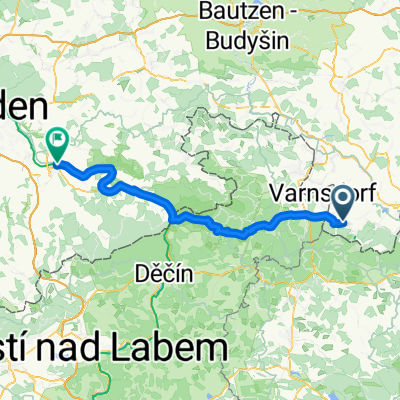
Trávník-Naděje-H.Světlá - D.Světlá-Mařenice-Lindava -Svitava-Maxov-Radvanec - Trávník CLONED FROM ROUTE 1516196
A cycling route starting in Kurort Jonsdorf, Saxony, Germany.
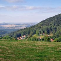
Overview
About this route
We start from Myslivna / Horní Světlá / small change
Trávník-Naděje-Hamr-Horní Světlá-Myslivny-Dolní Světlá-Juliovka-Mařenice-Mařeničky-Kunratice u Cvikova-Lindava-Svitava-Maxov Radvanec-Cvikov-Trávník
Radvanec - Trávník we weave through the forest.
These are first attempts!!!
- -:--
- Duration
- 36.9 km
- Distance
- 441 m
- Ascent
- 437 m
- Descent
- ---
- Avg. speed
- ---
- Max. altitude

Route quality
Waytypes & surfaces along the route
Waytypes
Road
18.1 km
(49 %)
Track
12.2 km
(33 %)
Surfaces
Paved
6.6 km
(18 %)
Unpaved
11.1 km
(30 %)
Asphalt
5.5 km
(15 %)
Gravel
5.2 km
(14 %)
Continue with Bikemap
Use, edit, or download this cycling route
You would like to ride Trávník-Naděje-H.Světlá - D.Světlá-Mařenice-Lindava -Svitava-Maxov-Radvanec - Trávník CLONED FROM ROUTE 1516196 or customize it for your own trip? Here is what you can do with this Bikemap route:
Free features
- Save this route as favorite or in collections
- Copy & plan your own version of this route
- Sync your route with Garmin or Wahoo
Premium features
Free trial for 3 days, or one-time payment. More about Bikemap Premium.
- Navigate this route on iOS & Android
- Export a GPX / KML file of this route
- Create your custom printout (try it for free)
- Download this route for offline navigation
Discover more Premium features.
Get Bikemap PremiumFrom our community
Other popular routes starting in Kurort Jonsdorf
 blue stone
- Distance
- 9.3 km
- Ascent
- 398 m
- Descent
- 303 m
- Location
- Kurort Jonsdorf, Saxony, Germany
 Jiřetín pod Jedlovou Eisgasse
- Distance
- 36.5 km
- Ascent
- 677 m
- Descent
- 893 m
- Location
- Kurort Jonsdorf, Saxony, Germany
 Jested Alternativ
- Distance
- 90.2 km
- Ascent
- 1,275 m
- Descent
- 1,289 m
- Location
- Kurort Jonsdorf, Saxony, Germany
 Trávník-Naděje-H.Světlá - D.Světlá-Mařenice-Lindava -Svitava-Maxov-Radvanec - Trávník CLONED FROM ROUTE 1516196
- Distance
- 36.9 km
- Ascent
- 441 m
- Descent
- 437 m
- Location
- Kurort Jonsdorf, Saxony, Germany
 Kurze Radrunde durch Jonsdorf
- Distance
- 7 km
- Ascent
- 295 m
- Descent
- 285 m
- Location
- Kurort Jonsdorf, Saxony, Germany
 Jonsdorf - Labska bouda
- Distance
- 219.2 km
- Ascent
- 2,662 m
- Descent
- 2,659 m
- Location
- Kurort Jonsdorf, Saxony, Germany
 Jonsdorfer Frühlingslauf 14 km
- Distance
- 12.5 km
- Ascent
- 422 m
- Descent
- 423 m
- Location
- Kurort Jonsdorf, Saxony, Germany
 Herbsttour Ostsachsen + Böhmische Schweiz, Tag 4
- Distance
- 71.5 km
- Ascent
- 805 m
- Descent
- 1,066 m
- Location
- Kurort Jonsdorf, Saxony, Germany
Open it in the app