

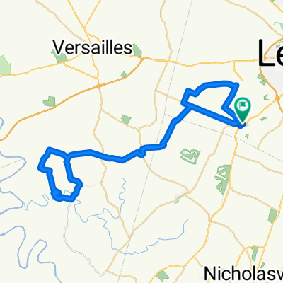
Ramsey's -- Hifner Loop
A cycling route starting in Monticello, Kentucky, United States.
Overview
About this route
- -:--
- Duration
- 55.5 km
- Distance
- 369 m
- Ascent
- 369 m
- Descent
- ---
- Avg. speed
- ---
- Max. altitude
Route quality
Waytypes & surfaces along the route
Waytypes
Quiet road
34.9 km
(63 %)
Road
14.4 km
(26 %)
Surfaces
Paved
19.4 km
(35 %)
Paved (undefined)
19.4 km
(35 %)
Undefined
36.1 km
(65 %)
Route highlights
Points of interest along the route
Point of interest after 36.6 km
MORTONSVILLE, KY
Point of interest after 37.1 km
Dogs on north side behind invisible fence
Continue with Bikemap
Use, edit, or download this cycling route
You would like to ride Ramsey's -- Hifner Loop or customize it for your own trip? Here is what you can do with this Bikemap route:
Free features
- Save this route as favorite or in collections
- Copy & plan your own version of this route
- Sync your route with Garmin or Wahoo
Premium features
Free trial for 3 days, or one-time payment. More about Bikemap Premium.
- Navigate this route on iOS & Android
- Export a GPX / KML file of this route
- Create your custom printout (try it for free)
- Download this route for offline navigation
Discover more Premium features.
Get Bikemap PremiumFrom our community
Other popular routes starting in Monticello
 Keeneland to Campbell House via Sam's Restaurant & Legacy Trail
- Distance
- 39.9 km
- Ascent
- 154 m
- Descent
- 152 m
- Location
- Monticello, Kentucky, United States
 Paul's Mill -- Versailles -- Keeneland Loop
- Distance
- 70.5 km
- Ascent
- 309 m
- Descent
- 312 m
- Location
- Monticello, Kentucky, United States
 Danville - Fayette Mall
- Distance
- 78.2 km
- Ascent
- 402 m
- Descent
- 443 m
- Location
- Monticello, Kentucky, United States
 Ramsey's - Nonesuch - Wilmore Y Loop
- Distance
- 57 km
- Ascent
- 253 m
- Descent
- 253 m
- Location
- Monticello, Kentucky, United States
 Ramsey's -- Hifner Loop
- Distance
- 55.5 km
- Ascent
- 369 m
- Descent
- 369 m
- Location
- Monticello, Kentucky, United States
 Ramseys to Mundy's Landing
- Distance
- 24.6 km
- Ascent
- 142 m
- Descent
- 248 m
- Location
- Monticello, Kentucky, United States
 Ramsey's to Millville via Clifton Rd
- Distance
- 49.2 km
- Ascent
- 299 m
- Descent
- 405 m
- Location
- Monticello, Kentucky, United States
 Versailles to Keeneland via Wms, Payne's Mill
- Distance
- 18.5 km
- Ascent
- 136 m
- Descent
- 147 m
- Location
- Monticello, Kentucky, United States
Open it in the app