
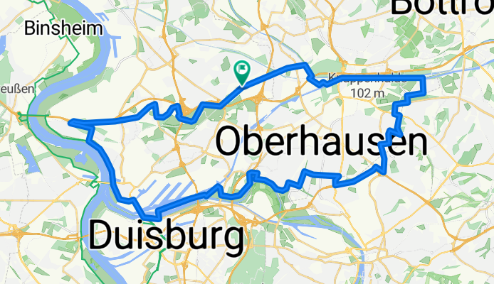
Emscher/Rhein-Herne-Kanal/Ruhr/ Rhein Runde
A cycling route starting in Meiderich, North Rhine-Westphalia, Germany.
Overview
About this route
Strecke ist besonders gut mit einem Trekking- oder Crossbike zu fahren.
- -:--
- Duration
- 43.1 km
- Distance
- 101 m
- Ascent
- 104 m
- Descent
- ---
- Avg. speed
- 55 m
- Max. altitude
Route quality
Waytypes & surfaces along the route
Waytypes
Path
13.3 km
(31 %)
Road
6.3 km
(15 %)
Surfaces
Paved
26.9 km
(62 %)
Unpaved
10.2 km
(24 %)
Asphalt
21.1 km
(49 %)
Gravel
7.9 km
(18 %)
Continue with Bikemap
Use, edit, or download this cycling route
You would like to ride Emscher/Rhein-Herne-Kanal/Ruhr/ Rhein Runde or customize it for your own trip? Here is what you can do with this Bikemap route:
Free features
- Save this route as favorite or in collections
- Copy & plan your own version of this route
- Sync your route with Garmin or Wahoo
Premium features
Free trial for 3 days, or one-time payment. More about Bikemap Premium.
- Navigate this route on iOS & Android
- Export a GPX / KML file of this route
- Create your custom printout (try it for free)
- Download this route for offline navigation
Discover more Premium features.
Get Bikemap PremiumFrom our community
Other popular routes starting in Meiderich
 Graf Mühle - Rotbach - Orsoy - Ruhrort
- Distance
- 70.5 km
- Ascent
- 97 m
- Descent
- 100 m
- Location
- Meiderich, North Rhine-Westphalia, Germany
 Meidrich-Orsoy-zurück
- Distance
- 43.8 km
- Ascent
- 94 m
- Descent
- 94 m
- Location
- Meiderich, North Rhine-Westphalia, Germany
 24h Duisburg
- Distance
- 7.8 km
- Ascent
- 42 m
- Descent
- 42 m
- Location
- Meiderich, North Rhine-Westphalia, Germany
 Rheinberg
- Distance
- 18.7 km
- Ascent
- 25 m
- Descent
- 29 m
- Location
- Meiderich, North Rhine-Westphalia, Germany
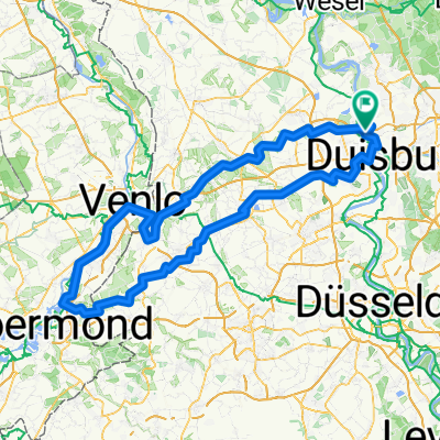 Duisburg-Brüggen-Venlo-Kaldenkirchen-Duisburg
- Distance
- 165.9 km
- Ascent
- 203 m
- Descent
- 204 m
- Location
- Meiderich, North Rhine-Westphalia, Germany
 HOAG-Route - Grüner Pfad (geschlossen am Rhein)
- Distance
- 32.5 km
- Ascent
- 83 m
- Descent
- 84 m
- Location
- Meiderich, North Rhine-Westphalia, Germany
 Rotbachrunde
- Distance
- 27.7 km
- Ascent
- 82 m
- Descent
- 69 m
- Location
- Meiderich, North Rhine-Westphalia, Germany
 Emscher/Rhein-Herne-Kanal/Ruhr/ Rhein Runde
- Distance
- 43.1 km
- Ascent
- 101 m
- Descent
- 104 m
- Location
- Meiderich, North Rhine-Westphalia, Germany
Open it in the app