

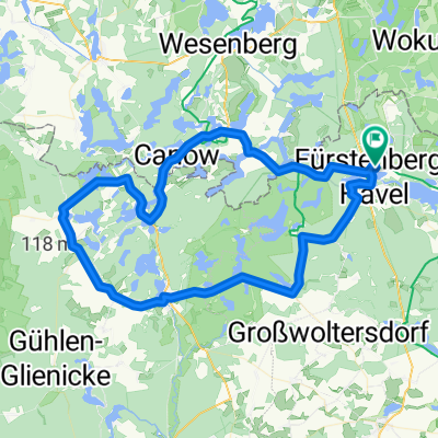
Müritz-Ruppiner-Land-Tour
A cycling route starting in Fürstenberg, Brandenburg, Germany.
Overview
About this route
Kurz vor Mirow an den Bahngleisen links auf den Fahrradweg abbiegen
- -:--
- Duration
- 141.8 km
- Distance
- 242 m
- Ascent
- 242 m
- Descent
- ---
- Avg. speed
- ---
- Max. altitude
Route quality
Waytypes & surfaces along the route
Waytypes
Busy road
66 km
(47 %)
Quiet road
33.3 km
(23 %)
Surfaces
Paved
94.8 km
(67 %)
Unpaved
7.1 km
(5 %)
Asphalt
92.2 km
(65 %)
Unpaved (undefined)
3.9 km
(3 %)
Continue with Bikemap
Use, edit, or download this cycling route
You would like to ride Müritz-Ruppiner-Land-Tour or customize it for your own trip? Here is what you can do with this Bikemap route:
Free features
- Save this route as favorite or in collections
- Copy & plan your own version of this route
- Split it into stages to create a multi-day tour
- Sync your route with Garmin or Wahoo
Premium features
Free trial for 3 days, or one-time payment. More about Bikemap Premium.
- Navigate this route on iOS & Android
- Export a GPX / KML file of this route
- Create your custom printout (try it for free)
- Download this route for offline navigation
Discover more Premium features.
Get Bikemap PremiumFrom our community
Other popular routes starting in Fürstenberg
 Fürstenberger Seenland
- Distance
- 56 km
- Ascent
- 248 m
- Descent
- 248 m
- Location
- Fürstenberg, Brandenburg, Germany
 Brandenburger Straße, Fürstenberg/Havel nach Camp am Ellbogensee, Fürstenberg/Havel
- Distance
- 8.9 km
- Ascent
- 90 m
- Descent
- 94 m
- Location
- Fürstenberg, Brandenburg, Germany
 Müritz-Ruppiner-Land-Tour
- Distance
- 141.8 km
- Ascent
- 242 m
- Descent
- 242 m
- Location
- Fürstenberg, Brandenburg, Germany
 Rheinsberger Seenland
- Distance
- 56.7 km
- Ascent
- 229 m
- Descent
- 229 m
- Location
- Fürstenberg, Brandenburg, Germany
 Seen Tour-de-McPommes '16
- Distance
- 266.9 km
- Ascent
- 168 m
- Descent
- 168 m
- Location
- Fürstenberg, Brandenburg, Germany
 Furstenberg/ Havel to Neustrelitz
- Distance
- 22.6 km
- Ascent
- 119 m
- Descent
- 102 m
- Location
- Fürstenberg, Brandenburg, Germany
 Durch kühle Buchenwälder
- Distance
- 37.8 km
- Ascent
- 346 m
- Descent
- 347 m
- Location
- Fürstenberg, Brandenburg, Germany
 perm Rheinsberger-Fürstenberger-Seentour
- Distance
- 78.3 km
- Ascent
- 399 m
- Descent
- 384 m
- Location
- Fürstenberg, Brandenburg, Germany
Open it in the app