

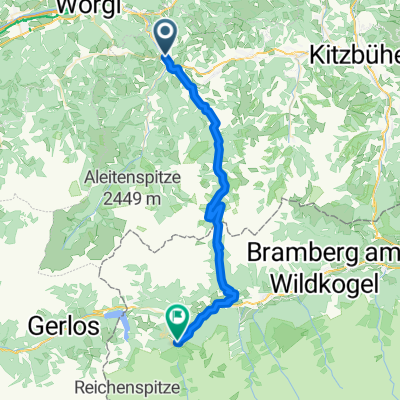
Rund um die Hohe Salve
A cycling route starting in Hopfgarten im Brixental, Tyrol, Austria.
Overview
About this route
- 3 h 42 min
- Duration
- 52.9 km
- Distance
- 933 m
- Ascent
- 928 m
- Descent
- 14.3 km/h
- Avg. speed
- 826 m
- Max. altitude

Route quality
Waytypes & surfaces along the route
Waytypes
Quiet road
30.7 km
(58 %)
Access road
5.8 km
(11 %)
Surfaces
Paved
48.2 km
(91 %)
Unpaved
3.7 km
(7 %)
Asphalt
47.1 km
(89 %)
Gravel
3.2 km
(6 %)
Continue with Bikemap
Use, edit, or download this cycling route
You would like to ride Rund um die Hohe Salve or customize it for your own trip? Here is what you can do with this Bikemap route:
Free features
- Save this route as favorite or in collections
- Copy & plan your own version of this route
- Sync your route with Garmin or Wahoo
Premium features
Free trial for 3 days, or one-time payment. More about Bikemap Premium.
- Navigate this route on iOS & Android
- Export a GPX / KML file of this route
- Create your custom printout (try it for free)
- Download this route for offline navigation
Discover more Premium features.
Get Bikemap PremiumFrom our community
Other popular routes starting in Hopfgarten im Brixental
 E-Bike Cup für Jedermann - Hohe Salve
- Distance
- 31.7 km
- Ascent
- 1,175 m
- Descent
- 1,160 m
- Location
- Hopfgarten im Brixental, Tyrol, Austria
 Von Hopfgarten bis Krimml
- Distance
- 41.9 km
- Ascent
- 1,882 m
- Descent
- 1,433 m
- Location
- Hopfgarten im Brixental, Tyrol, Austria
 L205, Hopfgarten im Brixental nach Wasserfeld, Hopfgarten im Brixental
- Distance
- 14.6 km
- Ascent
- 636 m
- Descent
- 628 m
- Location
- Hopfgarten im Brixental, Tyrol, Austria
 E-Bike Cup für Jedermann - Hohe Salve 2022
- Distance
- 31.6 km
- Ascent
- 1,115 m
- Descent
- 1,115 m
- Location
- Hopfgarten im Brixental, Tyrol, Austria
 ki6 Hopfgarten-KleineSalve
- Distance
- 11 km
- Ascent
- 659 m
- Descent
- 659 m
- Location
- Hopfgarten im Brixental, Tyrol, Austria
 Rund um die Hohe Salve
- Distance
- 52.9 km
- Ascent
- 933 m
- Descent
- 928 m
- Location
- Hopfgarten im Brixental, Tyrol, Austria
 Kaiserrunde
- Distance
- 102.4 km
- Ascent
- 1,006 m
- Descent
- 832 m
- Location
- Hopfgarten im Brixental, Tyrol, Austria
 A-AUT-Hopfgarten-Sterzing-125
- Distance
- 126.3 km
- Ascent
- 1,001 m
- Descent
- 686 m
- Location
- Hopfgarten im Brixental, Tyrol, Austria
Open it in the app