
Dienstag I
A cycling route starting in Horb am Neckar, Baden-Wurttemberg, Germany.
Overview
About this route
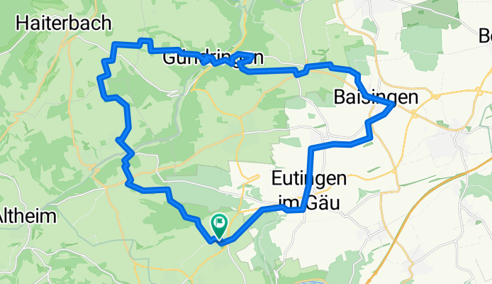
Schöne Tour über Bildechingen, Untertalheim, Gündringen, Vollmaringen, Baisingen, Eutingen und zurück nach Bildechingen.
Überwiegend Feldwege, auch mal nur Wiese, ab und zu Asphalt.
- -:--
- Duration
- 30.3 km
- Distance
- 411 m
- Ascent
- 411 m
- Descent
- ---
- Avg. speed
- ---
- Max. altitude
Continue with Bikemap
Use, edit, or download this cycling route
You would like to ride Dienstag I or customize it for your own trip? Here is what you can do with this Bikemap route:
Free features
- Save this route as favorite or in collections
- Copy & plan your own version of this route
- Sync your route with Garmin or Wahoo
Premium features
Free trial for 3 days, or one-time payment. More about Bikemap Premium.
- Navigate this route on iOS & Android
- Export a GPX / KML file of this route
- Create your custom printout (try it for free)
- Download this route for offline navigation
Discover more Premium features.
Get Bikemap PremiumFrom our community
Other popular routes starting in Horb am Neckar
 IHLINGEN BODENSEE
- Distance
- 104.3 km
- Ascent
- 1,769 m
- Descent
- 1,630 m
- Location
- Horb am Neckar, Baden-Wurttemberg, Germany
 Heubergstraße 7, Eutingen im Gäu nach Heubergstraße 5, Eutingen im Gäu
- Distance
- 20 km
- Ascent
- 89 m
- Descent
- 22 m
- Location
- Horb am Neckar, Baden-Wurttemberg, Germany
 Di4 - Im dunklen Wald
- Distance
- 32.8 km
- Ascent
- 610 m
- Descent
- 612 m
- Location
- Horb am Neckar, Baden-Wurttemberg, Germany
 DienstagII-um-den-Regen
- Distance
- 33.8 km
- Ascent
- 579 m
- Descent
- 581 m
- Location
- Horb am Neckar, Baden-Wurttemberg, Germany
 Dienstag 7 - Wo ist Malo
- Distance
- 30.4 km
- Ascent
- 572 m
- Descent
- 624 m
- Location
- Horb am Neckar, Baden-Wurttemberg, Germany
 Rommelstal, Neckar, Eutinger Tal
- Distance
- 37.8 km
- Ascent
- 640 m
- Descent
- 664 m
- Location
- Horb am Neckar, Baden-Wurttemberg, Germany
 Bildechingen-Haiterbach-Rundtour
- Distance
- 28.4 km
- Ascent
- 420 m
- Descent
- 420 m
- Location
- Horb am Neckar, Baden-Wurttemberg, Germany
 Bildechingen-Obernau-Starzach
- Distance
- 42.6 km
- Ascent
- 490 m
- Descent
- 560 m
- Location
- Horb am Neckar, Baden-Wurttemberg, Germany
Open it in the app