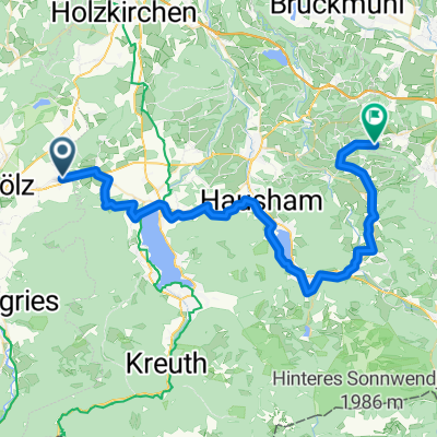
Kirchsteinhütte
A cycling route starting in Reichersbeuern, Bavaria, Germany.
Overview
About this route
21.4.12: We wanted to go to Benediktbeuern, but there was still snow above 1000 m. Then Kirchsteinhütte, but it was still closed (open from 22.4.). Total ascent about 1000 m.
- -:--
- Duration
- 42.1 km
- Distance
- 556 m
- Ascent
- 558 m
- Descent
- ---
- Avg. speed
- ---
- Max. altitude
Route quality
Waytypes & surfaces along the route
Waytypes
Track
16.4 km
(39 %)
Quiet road
11.8 km
(28 %)
Surfaces
Paved
20.2 km
(48 %)
Unpaved
19.4 km
(46 %)
Asphalt
17.3 km
(41 %)
Gravel
12.2 km
(29 %)
Continue with Bikemap
Use, edit, or download this cycling route
You would like to ride Kirchsteinhütte or customize it for your own trip? Here is what you can do with this Bikemap route:
Free features
- Save this route as favorite or in collections
- Copy & plan your own version of this route
- Sync your route with Garmin or Wahoo
Premium features
Free trial for 3 days, or one-time payment. More about Bikemap Premium.
- Navigate this route on iOS & Android
- Export a GPX / KML file of this route
- Create your custom printout (try it for free)
- Download this route for offline navigation
Discover more Premium features.
Get Bikemap PremiumFrom our community
Other popular routes starting in Reichersbeuern
- Relaxed Sonntag Ride In Reichersbeuern
- Distance
- 4.8 km
- Ascent
- 103 m
- Descent
- 51 m
- Location
- Reichersbeuern, Bavaria, Germany
- Kirchsteinhütte
- Distance
- 42.1 km
- Ascent
- 497 m
- Descent
- 498 m
- Location
- Reichersbeuern, Bavaria, Germany
- 6. september Rohrdorf 73km
- Distance
- 73.3 km
- Ascent
- 830 m
- Descent
- 1,068 m
- Location
- Reichersbeuern, Bavaria, Germany
- Kirchsteinhütte
- Distance
- 42.1 km
- Ascent
- 556 m
- Descent
- 558 m
- Location
- Reichersbeuern, Bavaria, Germany
- Reichersbeuern-Dietramszell-Isar
- Distance
- 56.1 km
- Ascent
- 473 m
- Descent
- 475 m
- Location
- Reichersbeuern, Bavaria, Germany
- Bodensee-Königssee-Radweg 06
- Distance
- 49.8 km
- Ascent
- 635 m
- Descent
- 742 m
- Location
- Reichersbeuern, Bavaria, Germany
- Sigrizalm am Rechelkopf
- Distance
- 17.3 km
- Ascent
- 550 m
- Descent
- 552 m
- Location
- Reichersbeuern, Bavaria, Germany
- Bad Tölz Obergries Isarrunde
- Distance
- 26 km
- Ascent
- 170 m
- Descent
- 173 m
- Location
- Reichersbeuern, Bavaria, Germany
Open it in the app