

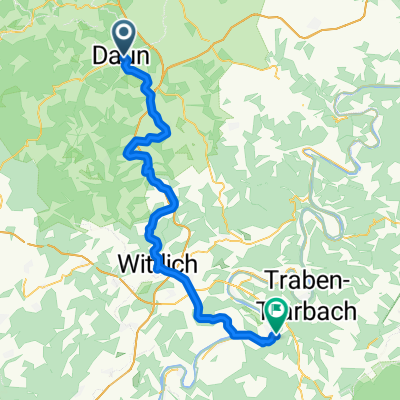
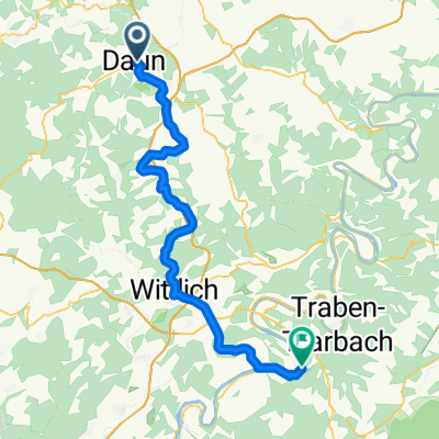
1999 Daun-Liesertal-Traben Trabach/Mosel
A cycling route starting in Daun, Rhineland-Palatinate, Germany.
Overview
About this route
erste Tour,am Holzmaar vom Bahntrassenweg abgebogen,Landstrasse,Abfahrt bei Schladt GNADENLOS...dann Wanderweg der Lieser Tal lang,nich radgeeignet stellenweise muss man absteigen...aber das tief eingeschnittene Tal kickt!
Mosel bis Traben Trabach
- -:--
- Duration
- 87.2 km
- Distance
- 313 m
- Ascent
- 588 m
- Descent
- ---
- Avg. speed
- ---
- Max. altitude
Route quality
Waytypes & surfaces along the route
Waytypes
Quiet road
19 km
(22 %)
Path
16.8 km
(19 %)
Surfaces
Paved
64.2 km
(74 %)
Unpaved
7.8 km
(9 %)
Asphalt
62.8 km
(72 %)
Gravel
3.5 km
(4 %)
Route highlights
Points of interest along the route
Point of interest after 1.9 km
Tunnel
Continue with Bikemap
Use, edit, or download this cycling route
You would like to ride 1999 Daun-Liesertal-Traben Trabach/Mosel or customize it for your own trip? Here is what you can do with this Bikemap route:
Free features
- Save this route as favorite or in collections
- Copy & plan your own version of this route
- Split it into stages to create a multi-day tour
- Sync your route with Garmin or Wahoo
Premium features
Free trial for 3 days, or one-time payment. More about Bikemap Premium.
- Navigate this route on iOS & Android
- Export a GPX / KML file of this route
- Create your custom printout (try it for free)
- Download this route for offline navigation
Discover more Premium features.
Get Bikemap PremiumFrom our community
Other popular routes starting in Daun
 Maare - Mosel Bahntrasse
- Distance
- 59.7 km
- Ascent
- 400 m
- Descent
- 665 m
- Location
- Daun, Rhineland-Palatinate, Germany
 Maare-Mosel-Radweg 090606
- Distance
- 58.2 km
- Ascent
- 370 m
- Descent
- 648 m
- Location
- Daun, Rhineland-Palatinate, Germany
 L3110 - détour vers Dronke-Turm
- Distance
- 3.3 km
- Ascent
- 142 m
- Descent
- 142 m
- Location
- Daun, Rhineland-Palatinate, Germany
 25 Daun Wittlich Mosel Maare Radweg
- Distance
- 42.3 km
- Ascent
- 203 m
- Descent
- 450 m
- Location
- Daun, Rhineland-Palatinate, Germany
 Maare-Mosel Radweg
- Distance
- 57.8 km
- Ascent
- 197 m
- Descent
- 469 m
- Location
- Daun, Rhineland-Palatinate, Germany
 4 Krater Tour
- Distance
- 55.4 km
- Ascent
- 887 m
- Descent
- 874 m
- Location
- Daun, Rhineland-Palatinate, Germany
 Pützborn-Schalkenmehren-Winkel-BadBertrich-Alf-Reil-Strotzbüsch-Gillenfeld-Gemünden-Pützborn
- Distance
- 108.1 km
- Ascent
- 940 m
- Descent
- 931 m
- Location
- Daun, Rhineland-Palatinate, Germany
 Dauner Runde 1. Teil
- Distance
- 75.1 km
- Ascent
- 886 m
- Descent
- 877 m
- Location
- Daun, Rhineland-Palatinate, Germany
Open it in the app