

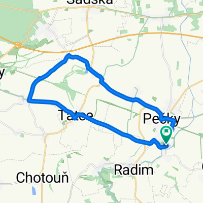
DOB-PLA-KOU-LIP-TAT-DOB
A cycling route starting in Pečky, Central Bohemia, Czechia.
Overview
About this route
Čím více zde napíšete informací, tím více bude užitečnější pro ostatním uživatele.* Průběh trasy.* Co je zvláštní na této trase?* Proč doporučit tuto trasu?* Co se Vám zde nejvíce líbilo?* Atd.
- -:--
- Duration
- 46.1 km
- Distance
- 304 m
- Ascent
- 303 m
- Descent
- ---
- Avg. speed
- ---
- Max. altitude

Route quality
Waytypes & surfaces along the route
Waytypes
Road
31.8 km
(69 %)
Quiet road
9.5 km
(21 %)
Surfaces
Paved
12.6 km
(27 %)
Asphalt
12.5 km
(27 %)
Paved (undefined)
0.1 km
(<1 %)
Undefined
33.5 km
(73 %)
Continue with Bikemap
Use, edit, or download this cycling route
You would like to ride DOB-PLA-KOU-LIP-TAT-DOB or customize it for your own trip? Here is what you can do with this Bikemap route:
Free features
- Save this route as favorite or in collections
- Copy & plan your own version of this route
- Sync your route with Garmin or Wahoo
Premium features
Free trial for 3 days, or one-time payment. More about Bikemap Premium.
- Navigate this route on iOS & Android
- Export a GPX / KML file of this route
- Create your custom printout (try it for free)
- Download this route for offline navigation
Discover more Premium features.
Get Bikemap PremiumFrom our community
Other popular routes starting in Pečky
 Dob-CBro-Bris-Sad-Pe-Dob
- Distance
- 42.3 km
- Ascent
- 166 m
- Descent
- 164 m
- Location
- Pečky, Central Bohemia, Czechia
 DOB-POD-NYM-SAD-DOB
- Distance
- 40.1 km
- Ascent
- 69 m
- Descent
- 69 m
- Location
- Pečky, Central Bohemia, Czechia
 DOB-PLA-KOU-LIP-TAT-DOB
- Distance
- 46.1 km
- Ascent
- 304 m
- Descent
- 303 m
- Location
- Pečky, Central Bohemia, Czechia
 DOB-CBRO-KOST-KOU-DOB
- Distance
- 52.2 km
- Ascent
- 316 m
- Descent
- 316 m
- Location
- Pečky, Central Bohemia, Czechia
 přes Chlumec n/C a Kopidlno
- Distance
- 125.2 km
- Ascent
- 302 m
- Descent
- 302 m
- Location
- Pečky, Central Bohemia, Czechia
 přes Český Štermberk
- Distance
- 129.1 km
- Ascent
- 829 m
- Descent
- 829 m
- Location
- Pečky, Central Bohemia, Czechia
 DOB-TAT-HOŘ-MIL-PE
- Distance
- 16.7 km
- Ascent
- 53 m
- Descent
- 51 m
- Location
- Pečky, Central Bohemia, Czechia
 DOB-TAT-HOŘ-SAD-NYM-POD-SOK-DOB
- Distance
- 46.5 km
- Ascent
- 67 m
- Descent
- 66 m
- Location
- Pečky, Central Bohemia, Czechia
Open it in the app