

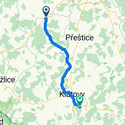
Kladruby, StareSedlo, H. Tyn, Poběžovice,
A cycling route starting in Stod, Plzeň Region, Czechia.
Overview
About this route
The more information you write here, the more useful it will be for other users.
- Route description.
- What is special about this route?
- Why recommend this route?
- What did you like most here?
- Etc.
- -:--
- Duration
- 90.8 km
- Distance
- 497 m
- Ascent
- 494 m
- Descent
- ---
- Avg. speed
- ---
- Max. altitude
Continue with Bikemap
Use, edit, or download this cycling route
You would like to ride Kladruby, StareSedlo, H. Tyn, Poběžovice, or customize it for your own trip? Here is what you can do with this Bikemap route:
Free features
- Save this route as favorite or in collections
- Copy & plan your own version of this route
- Split it into stages to create a multi-day tour
- Sync your route with Garmin or Wahoo
Premium features
Free trial for 3 days, or one-time payment. More about Bikemap Premium.
- Navigate this route on iOS & Android
- Export a GPX / KML file of this route
- Create your custom printout (try it for free)
- Download this route for offline navigation
Discover more Premium features.
Get Bikemap PremiumFrom our community
Other popular routes starting in Stod
 Holýšov - sv.Barnora - Honezovice - Kotovice
- Distance
- 38.6 km
- Ascent
- 635 m
- Descent
- 681 m
- Location
- Stod, Plzeň Region, Czechia
 Úzká do Mochtín
- Distance
- 43.8 km
- Ascent
- 419 m
- Descent
- 364 m
- Location
- Stod, Plzeň Region, Czechia
 Lengthy bike tour through Stod
- Distance
- 40.9 km
- Ascent
- 370 m
- Descent
- 367 m
- Location
- Stod, Plzeň Region, Czechia
 Hradec do Holýšov a zpět Hradec
- Distance
- 14.8 km
- Ascent
- 234 m
- Descent
- 234 m
- Location
- Stod, Plzeň Region, Czechia
 Hradecká, Stod do Americká 516, Holýšov
- Distance
- 8.4 km
- Ascent
- 143 m
- Descent
- 162 m
- Location
- Stod, Plzeň Region, Czechia
 Stod-Ves Touškov-Ostrov-Heřmanka-Nýřany-Uherce-Zbůch -Stod
- Distance
- 39.4 km
- Ascent
- 209 m
- Descent
- 211 m
- Location
- Stod, Plzeň Region, Czechia
 Stod - Přestavlky - Černotín - Dobřany - Chotěšov - Stod
- Distance
- 28.1 km
- Ascent
- 207 m
- Descent
- 210 m
- Location
- Stod, Plzeň Region, Czechia
 Kladruby, StareSedlo, H. Tyn, Poběžovice,
- Distance
- 90.8 km
- Ascent
- 497 m
- Descent
- 494 m
- Location
- Stod, Plzeň Region, Czechia
Open it in the app