

Trilha do EitaPorra! Marechal-B. de São Miguel
A cycling route starting in Marechal Deodoro, Alagoas, Brazil.
Overview
About this route
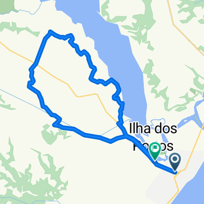
Jungle trail!! You need a somewhat experienced guide, as the paths are complicated and cause doubts.
Trail featuring sugarcane fields, slopes (uphills and downhills), lots of nature, river bathing, some sand, lagoon, and perfect landscapes... real jungle!
Tip: leave the car at the Francês gas station or at the Bahia bar (as everyone does).
The mud ends near Barra de São Miguel, where you will have to return cycling on the road back to the support point at Francês.
Note: Watch for the small detour on the route. At this detour is the river bath.
- -:--
- Duration
- 31.5 km
- Distance
- 243 m
- Ascent
- 241 m
- Descent
- ---
- Avg. speed
- ---
- Max. altitude

Continue with Bikemap
Use, edit, or download this cycling route
You would like to ride Trilha do EitaPorra! Marechal-B. de São Miguel or customize it for your own trip? Here is what you can do with this Bikemap route:
Free features
- Save this route as favorite or in collections
- Copy & plan your own version of this route
- Sync your route with Garmin or Wahoo
Premium features
Free trial for 3 days, or one-time payment. More about Bikemap Premium.
- Navigate this route on iOS & Android
- Export a GPX / KML file of this route
- Create your custom printout (try it for free)
- Download this route for offline navigation
Discover more Premium features.
Get Bikemap PremiumFrom our community
Other popular routes starting in Marechal Deodoro
 taperagua/usina/Fernandes Lima/Denissom
- Distance
- 20.5 km
- Ascent
- 122 m
- Descent
- 123 m
- Location
- Marechal Deodoro, Alagoas, Brazil
 rio periquito e rio do inhame
- Distance
- 42.6 km
- Ascent
- 230 m
- Descent
- 213 m
- Location
- Marechal Deodoro, Alagoas, Brazil
 Trilha do EitaPorra! Marechal-B. de São Miguel
- Distance
- 31.5 km
- Ascent
- 256 m
- Descent
- 254 m
- Location
- Marechal Deodoro, Alagoas, Brazil
 PASSAGEM POR MARECHAL DEODORO
- Distance
- 4 km
- Ascent
- 94 m
- Descent
- 64 m
- Location
- Marechal Deodoro, Alagoas, Brazil
 Rota relaxada em Marechal Deodoro
- Distance
- 8 km
- Ascent
- 8 m
- Descent
- 4 m
- Location
- Marechal Deodoro, Alagoas, Brazil
 Trilha Lago Azul
- Distance
- 39.4 km
- Ascent
- 166 m
- Descent
- 169 m
- Location
- Marechal Deodoro, Alagoas, Brazil
 DESAFIO INTERNACIONAL DE CICLISMO - PERCURSO 12/11
- Distance
- 126 km
- Ascent
- 696 m
- Descent
- 563 m
- Location
- Marechal Deodoro, Alagoas, Brazil
 denissom x rio da geladeira
- Distance
- 43.7 km
- Ascent
- 395 m
- Descent
- 388 m
- Location
- Marechal Deodoro, Alagoas, Brazil
Open it in the app