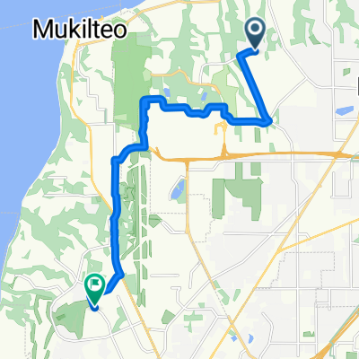
short mtn bike loop
A cycling route starting in Mukilteo, Washington, United States of America.
Overview
About this route
A nice loop for a quick heart-rate boost. Stop at Mukilteo beach can be omitted if time is short. Trails in Japanese Gulch invite further exploration. Does anybody put out a map of the Gulch? It's popular with mtn. bikers.
- -:--
- Duration
- 17.2 km
- Distance
- 255 m
- Ascent
- 257 m
- Descent
- ---
- Avg. speed
- ---
- Avg. speed
Route quality
Waytypes & surfaces along the route
Waytypes
Busy road
4.1 km
(24 %)
Road
3.6 km
(21 %)
Surfaces
Paved
8.8 km
(52 %)
Unpaved
3.5 km
(20 %)
Asphalt
8.5 km
(49 %)
Ground
1.9 km
(11 %)
Continue with Bikemap
Use, edit, or download this cycling route
You would like to ride short mtn bike loop or customize it for your own trip? Here is what you can do with this Bikemap route:
Free features
- Save this route as favorite or in collections
- Copy & plan your own version of this route
- Sync your route with Garmin or Wahoo
Premium features
Free trial for 3 days, or one-time payment. More about Bikemap Premium.
- Navigate this route on iOS & Android
- Export a GPX / KML file of this route
- Create your custom printout (try it for free)
- Download this route for offline navigation
Discover more Premium features.
Get Bikemap PremiumFrom our community
Other popular routes starting in Mukilteo
- Everett to Skagit County Line via Centennial Trail
- Distance
- 64.8 km
- Ascent
- 248 m
- Descent
- 294 m
- Location
- Mukilteo, Washington, United States of America
- Everett to Lk Washington Loop
- Distance
- 132.8 km
- Ascent
- 643 m
- Descent
- 643 m
- Location
- Mukilteo, Washington, United States of America
- Everett to LaConner
- Distance
- 81.2 km
- Ascent
- 200 m
- Descent
- 318 m
- Location
- Mukilteo, Washington, United States of America
- USA - Mukilteo: Pudget Sound Discovery Tour
- Distance
- 156.8 km
- Ascent
- 735 m
- Descent
- 735 m
- Location
- Mukilteo, Washington, United States of America
- Relaxed route in Mukilteo
- Distance
- 5.7 km
- Ascent
- 218 m
- Descent
- 215 m
- Location
- Mukilteo, Washington, United States of America
- 4 Lighthouse Century
- Distance
- 198.8 km
- Ascent
- 945 m
- Descent
- 945 m
- Location
- Mukilteo, Washington, United States of America
- Everett-Maple Valley 4 Trails
- Distance
- 174.4 km
- Ascent
- 458 m
- Descent
- 458 m
- Location
- Mukilteo, Washington, United States of America
- Everett-LaConner-Whidbey Loop
- Distance
- 195.7 km
- Ascent
- 727 m
- Descent
- 726 m
- Location
- Mukilteo, Washington, United States of America
Open it in the app