

BCB-10º Aniversario. Las Hormazas. Oficial
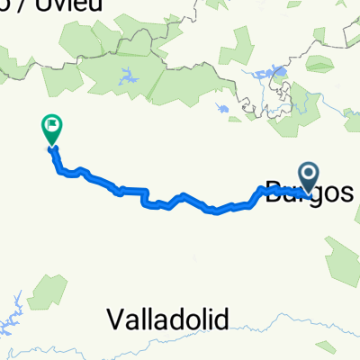
A cycling route starting in Burgos, Castille and León, Spain.
Overview
About this route
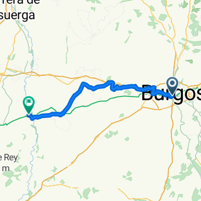
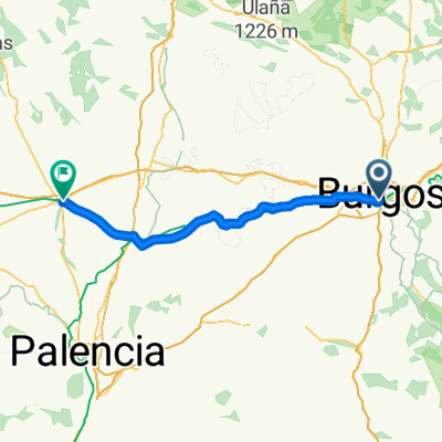
Route organized by BurgosConBici to celebrate its tenth anniversary. This is the official proposal. It is a circular route to be done in two days, with an overnight stay in Las Hormazas. It passes through typically Castilian valleys and plateaus. The valleys have beautiful spots and the plateaus offer wide views. Almost the entire route runs on secondary roads with barely any traffic. It passes through several villages with some artistic and monumental interest. It is ideal for families. It can even serve as an introductory route for children.
- -:--
- Duration
- 79 km
- Distance
- 457 m
- Ascent
- 457 m
- Descent
- ---
- Avg. speed
- ---
- Max. altitude

Route quality
Waytypes & surfaces along the route
Waytypes
Track
28.4 km
(36 %)
Road
26.1 km
(33 %)
Surfaces
Paved
40.3 km
(51 %)
Unpaved
28.4 km
(36 %)
Asphalt
39.5 km
(50 %)
Unpaved (undefined)
15 km
(19 %)
Route highlights
Points of interest along the route

Point of interest after 10.3 km
Arroyal

Point of interest after 26.7 km
Los Tremellos. Propuesta para la comida el primer día de ruta. En el entorno de la Iglesia.

Point of interest after 35.5 km
Local cedido por el Ayuntamiento de Las Hormazas para la cena, fiesta y pernocta

Point of interest after 36.1 km
Ermita del Castillo. Las Hormazas. Cena, Fiesta y pernocta

Point of interest after 36.8 km
Ermita del Castillo. Las Hormazas.

Point of interest after 37.2 km
10 ºAniversario de BurgosConBici

Point of interest after 51.6 km
Ermita de Nuestra Señora de Argaño. Lugar propuesto para la comida del segundo día. Hay fuente y mesas con bancos. ¡IMPORTANTE! Este no es el punto intermedio de la etapa. Aún quedan 25 Km para llegar a Burgos. Si vas con niños, tenlo en cuenta. Se les puede hacer pesado. Sobre todo la cuesta entre Hornillos y Rabé. Quizá prefieras aplazar la comida hasta más adelante. Hay un Merendero al lado del camino, cerca ya de Rabé
Point of interest after 53.4 km
¡Atención, atención! Cruce peligroso. Hay que cruzar la N-120 para llegar a Hornillos del Camino y coger el Camino de Santiago. La carretera que lleva a Hornillos es cómoda, pero para evitar coches, hay un camino que une Villanueva de Argaño y Hornillos. Para cogerlo hay que circular por la N-120 hasta Villanueva y coger la primera calle a la izquierda.

Point of interest after 71.1 km
Cruce peligroso. En este punto hay que cruzar la N-120 para seguir ruta por el camino de Santiago. ¡Cuidado con los niños! Tenemos la posibilidad de no cruzar y seguir la pista que nos trae de Tardajos por la margen derecha de la carretera. Esta nos acercaría a la vía y, dando un rodeon, pasaríamos por debajo de la autovía y de la N-120 más cerca de Villalbilla, para acabaríamos conectando con el Camino de Santiago.
Continue with Bikemap
Use, edit, or download this cycling route
You would like to ride BCB-10º Aniversario. Las Hormazas. Oficial or customize it for your own trip? Here is what you can do with this Bikemap route:
Free features
- Save this route as favorite or in collections
- Copy & plan your own version of this route
- Sync your route with Garmin or Wahoo
Premium features
Free trial for 3 days, or one-time payment. More about Bikemap Premium.
- Navigate this route on iOS & Android
- Export a GPX / KML file of this route
- Create your custom printout (try it for free)
- Download this route for offline navigation
Discover more Premium features.
Get Bikemap PremiumFrom our community
Other popular routes starting in Burgos
 Burgos - León
- Distance
- 220.9 km
- Ascent
- 1,239 m
- Descent
- 1,262 m
- Location
- Burgos, Castille and León, Spain
 Burgos - Itero de la Vega
- Distance
- 64.5 km
- Ascent
- 575 m
- Descent
- 668 m
- Location
- Burgos, Castille and León, Spain
 Anormalidad 2.0 - Sanctuary
- Distance
- 37.8 km
- Ascent
- 433 m
- Descent
- 416 m
- Location
- Burgos, Castille and León, Spain
 2025. 1 nap El Camino
- Distance
- 86.3 km
- Ascent
- 535 m
- Descent
- 565 m
- Location
- Burgos, Castille and León, Spain
 Calle de San Pablo, Burgos to Burgos
- Distance
- 11.4 km
- Ascent
- 39 m
- Descent
- 42 m
- Location
- Burgos, Castille and León, Spain
 Calle de San Pablo, Burgos to Calle del Progreso, Burgos
- Distance
- 11.4 km
- Ascent
- 86 m
- Descent
- 92 m
- Location
- Burgos, Castille and León, Spain
 Calle de San Pablo, Burgos to Calle del Progreso, Burgos
- Distance
- 12.2 km
- Ascent
- 120 m
- Descent
- 123 m
- Location
- Burgos, Castille and León, Spain
 Anormalidad 0.1
- Distance
- 45.8 km
- Ascent
- 242 m
- Descent
- 242 m
- Location
- Burgos, Castille and León, Spain
Open it in the app