Weidenhöfen-Strecke
A cycling route starting in Weitra, Lower Austria, Austria.
Overview
About this route
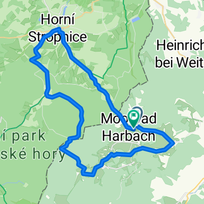
Vor dem Stadttor beginnt unsere Tour, wo wir nach dem Kreisverkehr die 2. Ausfahrt Richtung Veitsgraben nehmen, die uns unter einem Viadukt der Schmalspurbahn in Richtung Spital führt. Dort biegen wir nach links ab, wo uns die Tour nach Überquerung der Bundesstraße 199 hinunter nach Weidenhöfen führt. Dort folgen wir der Straße nach Wetzles, hier verlassen wir die Landesstraße und kommen über einen Feldweg nach Ulrichs. Dort biegen wir links ab zum Ulrichs Teich, danach folgen wir dem Straßenverlauf wieder bis Weitra.
- -:--
- Duration
- 14.2 km
- Distance
- 200 m
- Ascent
- 198 m
- Descent
- ---
- Avg. speed
- ---
- Avg. speed
Route quality
Waytypes & surfaces along the route
Waytypes
Track
8.1 km
(57 %)
Quiet road
3.6 km
(26 %)
Surfaces
Paved
5.5 km
(39 %)
Unpaved
4.5 km
(31 %)
Asphalt
3.5 km
(25 %)
Gravel
3.1 km
(22 %)
Continue with Bikemap
Use, edit, or download this cycling route
You would like to ride Weidenhöfen-Strecke or customize it for your own trip? Here is what you can do with this Bikemap route:
Free features
- Save this route as favorite or in collections
- Copy & plan your own version of this route
- Sync your route with Garmin or Wahoo
Premium features
Free trial for 3 days, or one-time payment. More about Bikemap Premium.
- Navigate this route on iOS & Android
- Export a GPX / KML file of this route
- Create your custom printout (try it for free)
- Download this route for offline navigation
Discover more Premium features.
Get Bikemap PremiumFrom our community
Other popular routes starting in Weitra
- nebelstein
- Distance
- 14.7 km
- Ascent
- 362 m
- Descent
- 360 m
- Location
- Weitra, Lower Austria, Austria
- Weitra - Gmünd
- Distance
- 14.3 km
- Ascent
- 40 m
- Descent
- 127 m
- Location
- Weitra, Lower Austria, Austria
- Europastrecke
- Distance
- 23.8 km
- Ascent
- 357 m
- Descent
- 357 m
- Location
- Weitra, Lower Austria, Austria
- Weitra Busbahnhof (Sparkassenplatz) nach Harbach
- Distance
- 12.2 km
- Ascent
- 196 m
- Descent
- 87 m
- Location
- Weitra, Lower Austria, Austria
- Bildbaumweg 1, Sejby Horní Strobnice Hojná Voda Hirschwiesen Lauterbach nach Bildbaumweg 1, Lauterbach
- Distance
- 23.9 km
- Ascent
- 443 m
- Descent
- 441 m
- Location
- Weitra, Lower Austria, Austria
- Radtour2014-1
- Distance
- 86.7 km
- Ascent
- 693 m
- Descent
- 884 m
- Location
- Weitra, Lower Austria, Austria
- Wultschau
- Distance
- 58.8 km
- Ascent
- 1,041 m
- Descent
- 1,041 m
- Location
- Weitra, Lower Austria, Austria
- Lainsitztal2-Neu
- Distance
- 53.6 km
- Ascent
- 622 m
- Descent
- 1,013 m
- Location
- Weitra, Lower Austria, Austria
Open it in the app