Europastrecke
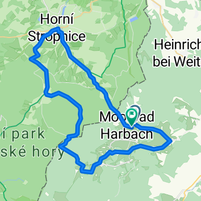
A cycling route starting in Weitra, Lower Austria, Austria.
Overview
About this route
The tour begins in front of the city gate heading towards Tiefenbach, where there is a steep descent. After that, you must make a sharp left turn. Crossing the Lainsitz river, you head to the right where you encounter a forest road. We follow this until the state road 71, where we turn right and continue cycling on asphalt towards Schagges, Heinrichs, and Phyrabruck. (Here, the route could be extended into the Czech Republic, where the border town Nové Hrady is reachable in 3 km.)
From here, the route takes us through Reinprechts and Höhenberg to Unterlembach, where we follow the Granittrail all the way to Weitra.
- -:--
- Duration
- 23.8 km
- Distance
- 357 m
- Ascent
- 357 m
- Descent
- ---
- Avg. speed
- ---
- Max. altitude
Route quality
Waytypes & surfaces along the route
Waytypes
Road
13.3 km
(56 %)
Quiet road
1.2 km
(5 %)
Undefined
9.3 km
(39 %)
Surfaces
Paved
10 km
(42 %)
Asphalt
10 km
(42 %)
Undefined
13.8 km
(58 %)
Continue with Bikemap
Use, edit, or download this cycling route
You would like to ride Europastrecke or customize it for your own trip? Here is what you can do with this Bikemap route:
Free features
- Save this route as favorite or in collections
- Copy & plan your own version of this route
- Sync your route with Garmin or Wahoo
Premium features
Free trial for 3 days, or one-time payment. More about Bikemap Premium.
- Navigate this route on iOS & Android
- Export a GPX / KML file of this route
- Create your custom printout (try it for free)
- Download this route for offline navigation
Discover more Premium features.
Get Bikemap PremiumFrom our community
Other popular routes starting in Weitra
Via Verde Hauptstrecke umgekehrt- Distance
- 30.8 km
- Ascent
- 617 m
- Descent
- 619 m
- Location
- Weitra, Lower Austria, Austria
Bildbaumweg nach Bildbaumweg- Distance
- 31.3 km
- Ascent
- 601 m
- Descent
- 639 m
- Location
- Weitra, Lower Austria, Austria
Wultschau- Distance
- 58.8 km
- Ascent
- 1,041 m
- Descent
- 1,041 m
- Location
- Weitra, Lower Austria, Austria
Bildbaumweg 1, Sejby Hornà Strobnice Hojná Voda Hirschwiesen Lauterbach nach Bildbaumweg 1, Lauterbach- Distance
- 23.9 km
- Ascent
- 443 m
- Descent
- 441 m
- Location
- Weitra, Lower Austria, Austria
Radtour2014-1- Distance
- 86.7 km
- Ascent
- 693 m
- Descent
- 884 m
- Location
- Weitra, Lower Austria, Austria
Europastrecke- Distance
- 23.8 km
- Ascent
- 357 m
- Descent
- 357 m
- Location
- Weitra, Lower Austria, Austria
nebelstein- Distance
- 14.7 km
- Ascent
- 362 m
- Descent
- 360 m
- Location
- Weitra, Lower Austria, Austria
Weitra Busbahnhof (Sparkassenplatz) nach Harbach- Distance
- 12.2 km
- Ascent
- 196 m
- Descent
- 87 m
- Location
- Weitra, Lower Austria, Austria
Open it in the app


