![9, 아산시Ph0]으로 라우팅](/_next/static/media/contour-lines-light-small.cafd5e5d.avif)
![9, 아산시Ph0]으로 라우팅](https://media.bikemap.net/routes/15331317/staticmaps/in_c9691044-12a6-4fe8-979f-2386ae8eb40b_694x400_bikemap-2021-3D-static.png)
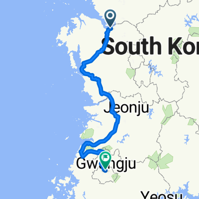
9, 아산시Ph0]으로 라우팅
A cycling route starting in Asan, Chungcheongnam-do, South Korea.
Overview
About this route
- 58 min
- Duration
- 16.7 km
- Distance
- 33 m
- Ascent
- 52 m
- Descent
- 17.4 km/h
- Avg. speed
- 39 m
- Max. altitude
Continue with Bikemap
Use, edit, or download this cycling route
You would like to ride 9, 아산시Ph0]으로 라우팅 or customize it for your own trip? Here is what you can do with this Bikemap route:
Free features
- Save this route as favorite or in collections
- Copy & plan your own version of this route
- Sync your route with Garmin or Wahoo
Premium features
Free trial for 3 days, or one-time payment. More about Bikemap Premium.
- Navigate this route on iOS & Android
- Export a GPX / KML file of this route
- Create your custom printout (try it for free)
- Download this route for offline navigation
Discover more Premium features.
Get Bikemap PremiumFrom our community
Other popular routes starting in Asan
 От 307-3 권곡동, 아산시 до 697 신부동, 천안시
- Distance
- 20.3 km
- Ascent
- 1,075 m
- Descent
- 1,040 m
- Location
- Asan, Chungcheongnam-do, South Korea
 용화동, 아산시 to 용화동, 아산시
- Distance
- 51.4 km
- Ascent
- 237 m
- Descent
- 231 m
- Location
- Asan, Chungcheongnam-do, South Korea
 маршрут с Sinchang-myeon 17, Asan-si
- Distance
- 7.1 km
- Ascent
- 67 m
- Descent
- 86 m
- Location
- Asan, Chungcheongnam-do, South Korea
 용화동, 아산시 to 용화동, 아산시
- Distance
- 36.9 km
- Ascent
- 206 m
- Descent
- 208 m
- Location
- Asan, Chungcheongnam-do, South Korea
 pilgrim of winniethepoo family
- Distance
- 338.6 km
- Ascent
- 3,529 m
- Descent
- 3,512 m
- Location
- Asan, Chungcheongnam-do, South Korea
 2025.9.7 저녁
- Distance
- 30.4 km
- Ascent
- 184 m
- Descent
- 223 m
- Location
- Asan, Chungcheongnam-do, South Korea
 2025.8.28오후
- Distance
- 44.8 km
- Ascent
- 199 m
- Descent
- 194 m
- Location
- Asan, Chungcheongnam-do, South Korea
 용화고길, 아산시 to 용화동, 아산시
- Distance
- 63.3 km
- Ascent
- 201 m
- Descent
- 200 m
- Location
- Asan, Chungcheongnam-do, South Korea
Open it in the app