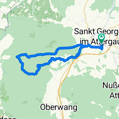
Felvétel az Apple Watch-on keresztül 18.8. 17:54
A cycling route starting in Sankt Georgen im Attergau, Upper Austria, Austria.
Overview
About this route
- 5 h 7 min
- Duration
- 58.2 km
- Distance
- 820 m
- Ascent
- 817 m
- Descent
- 11.4 km/h
- Avg. speed
- 646 m
- Avg. speed
Route photos
Route quality
Waytypes & surfaces along the route
Waytypes
Busy road
25.8 km
(44 %)
Quiet road
14.3 km
(25 %)
Surfaces
Paved
40.1 km
(69 %)
Unpaved
0.4 km
(<1 %)
Asphalt
39.1 km
(67 %)
Paving stones
1 km
(2 %)
Continue with Bikemap
Use, edit, or download this cycling route
You would like to ride Felvétel az Apple Watch-on keresztül 18.8. 17:54 or customize it for your own trip? Here is what you can do with this Bikemap route:
Free features
- Save this route as favorite or in collections
- Copy & plan your own version of this route
- Sync your route with Garmin or Wahoo
Premium features
Free trial for 3 days, or one-time payment. More about Bikemap Premium.
- Navigate this route on iOS & Android
- Export a GPX / KML file of this route
- Create your custom printout (try it for free)
- Download this route for offline navigation
Discover more Premium features.
Get Bikemap PremiumFrom our community
Other popular routes starting in Sankt Georgen im Attergau
- Felvétel az Apple Watch-on keresztül 18.8. 17:54
- Distance
- 58.2 km
- Ascent
- 820 m
- Descent
- 817 m
- Location
- Sankt Georgen im Attergau, Upper Austria, Austria
- kleine leichte Lichtenbergrunde
- Distance
- 13.4 km
- Ascent
- 413 m
- Descent
- 421 m
- Location
- Sankt Georgen im Attergau, Upper Austria, Austria
- awv92a-St.Georgen-Schörfling-Gmunden-Ebensee
- Distance
- 49.6 km
- Ascent
- 306 m
- Descent
- 453 m
- Location
- Sankt Georgen im Attergau, Upper Austria, Austria
- hochplettrunde
- Distance
- 47.6 km
- Ascent
- 979 m
- Descent
- 975 m
- Location
- Sankt Georgen im Attergau, Upper Austria, Austria
- Kronberg-Lichtenberg-Kronberg
- Distance
- 23.2 km
- Ascent
- 514 m
- Descent
- 516 m
- Location
- Sankt Georgen im Attergau, Upper Austria, Austria
- Circuit 3 Mondsee-Irsee
- Distance
- 62.6 km
- Ascent
- 475 m
- Descent
- 477 m
- Location
- Sankt Georgen im Attergau, Upper Austria, Austria
- 24/06 52 km Attersee (Sankt Georgen) - Obertrattnach po vlak doPassau
- Distance
- 59.5 km
- Ascent
- 670 m
- Descent
- 853 m
- Location
- Sankt Georgen im Attergau, Upper Austria, Austria
- MTB Bf>Mitterl.24/350
- Distance
- 24 km
- Ascent
- 414 m
- Descent
- 414 m
- Location
- Sankt Georgen im Attergau, Upper Austria, Austria