

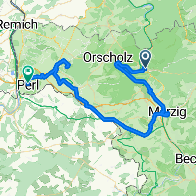
FR1-3b_Mettlach - Perl_72,6km 290hm
A cycling route starting in Mettlach, Saarland, Germany.
Overview
About this route
- 4 h 44 min
- Duration
- 72.4 km
- Distance
- 781 m
- Ascent
- 824 m
- Descent
- 15.3 km/h
- Avg. speed
- 226 m
- Max. altitude

Route quality
Waytypes & surfaces along the route
Waytypes
Path
37.4 km
(52 %)
Track
14.5 km
(20 %)
Surfaces
Paved
62.1 km
(86 %)
Unpaved
8.1 km
(11 %)
Asphalt
50.9 km
(70 %)
Gravel
6.7 km
(9 %)
Route highlights
Points of interest along the route
Point of interest after 1.3 km
Lutwinuskapelle Mettlach
Point of interest after 2.6 km
Kleiner Wasserfall
Point of interest after 4.2 km
Blick zum Vogelfelsen
Point of interest after 5.7 km
Kapellenblick
Point of interest after 6.5 km
Blick auf den roten Berg
Point of interest after 7.8 km
Steinbruch bei Taben-Rodt
Point of interest after 8.3 km
Selbstbedienung
Point of interest after 11.2 km
Rastplatz
Point of interest after 13.6 km
Schiffsschleuse Serrig
Point of interest after 20.4 km
WC
Point of interest after 20.5 km
Städtchen um einen Wasserfall gebaut
Bike service after 20.5 km
Point of interest after 20.8 km
Burgblick
Point of interest after 24 km
Biotop bei Biebelhausen
Point of interest after 31.7 km
Mündung der Saar in die Mosel
Point of interest after 38.8 km
Pause
Point of interest after 39 km
WC
Point of interest after 39.4 km
WC
Bike service after 39.6 km
Point of interest after 40.2 km
Blick auf Mertert
Point of interest after 41.7 km
Schloß Temmels
Point of interest after 49 km
Nitteler Stein
Point of interest after 54.9 km
A verrost's Haus... bestimmt sauteurer Vintagelook
Point of interest after 61.8 km
Steine am Fluß
Point of interest after 62.4 km
Opa Schuler - Ristaurante L' Italiano
Point of interest after 65.7 km
Tiefster Punkt Saarland
Point of interest after 69.1 km
Überdachter Rastplatz am Mosel-Radweg
Point of interest after 69.5 km
Hungerstein "Besch"
Bike service after 69.6 km
Accommodation after 70.9 km
Sonnenhof Merziger Str. 3, 66706 Perl
Continue with Bikemap
Use, edit, or download this cycling route
You would like to ride FR1-3b_Mettlach - Perl_72,6km 290hm or customize it for your own trip? Here is what you can do with this Bikemap route:
Free features
- Save this route as favorite or in collections
- Copy & plan your own version of this route
- Sync your route with Garmin or Wahoo
Premium features
Free trial for 3 days, or one-time payment. More about Bikemap Premium.
- Navigate this route on iOS & Android
- Export a GPX / KML file of this route
- Create your custom printout (try it for free)
- Download this route for offline navigation
Discover more Premium features.
Get Bikemap PremiumFrom our community
Other popular routes starting in Mettlach
 RLP4a: Mettlach - Holsthum, 72,3km 232hm
- Distance
- 72.3 km
- Ascent
- 232 m
- Descent
- 200 m
- Location
- Mettlach, Saarland, Germany
 Saarschleife
- Distance
- 37.8 km
- Ascent
- 386 m
- Descent
- 385 m
- Location
- Mettlach, Saarland, Germany
 Dreiländereck light
- Distance
- 68.1 km
- Ascent
- 644 m
- Descent
- 644 m
- Location
- Mettlach, Saarland, Germany
 Zum Saarradweg über Aussicht
- Distance
- 13.3 km
- Ascent
- 323 m
- Descent
- 333 m
- Location
- Mettlach, Saarland, Germany
 3. Etappe - Heinertstraße, Mettlach nach Trierer Straße, Perl
- Distance
- 51.6 km
- Ascent
- 768 m
- Descent
- 711 m
- Location
- Mettlach, Saarland, Germany
 FR1-3b_Mettlach - Perl_72,6km 290hm
- Distance
- 72.4 km
- Ascent
- 781 m
- Descent
- 824 m
- Location
- Mettlach, Saarland, Germany
 Saar- , Mosel- & Rheinradweg von Mettlach bis Düsseldorf
- Distance
- 394.8 km
- Ascent
- 114 m
- Descent
- 251 m
- Location
- Mettlach, Saarland, Germany
 Mettlach, Saarburg, Konz
- Distance
- 70.4 km
- Ascent
- 354 m
- Descent
- 352 m
- Location
- Mettlach, Saarland, Germany
Open it in the app