

Luž-Naděje-Trávník-Sloup-Mařenice CLONED FROM ROUTE 1531852
A cycling route starting in Kurort Jonsdorf, Saxony, Germany.
Overview
About this route
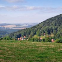
Druhý den cyklo pobytu na Luži. Velký sjezd a mírně zvlněné. většinou silničky. sem tam terének. Legrace.
Výborná hospůdka v Radvanci, velmi nízké ceny, kvalitní kuchyně, obsluhuje dobrodruh cestovatel.
- -:--
- Duration
- 38.8 km
- Distance
- 292 m
- Ascent
- 560 m
- Descent
- ---
- Avg. speed
- ---
- Max. altitude

Route quality
Waytypes & surfaces along the route
Waytypes
Road
19.8 km
(51 %)
Track
9.3 km
(24 %)
Surfaces
Paved
10.5 km
(27 %)
Unpaved
8.9 km
(23 %)
Asphalt
9.3 km
(24 %)
Gravel
3.5 km
(9 %)
Continue with Bikemap
Use, edit, or download this cycling route
You would like to ride Luž-Naděje-Trávník-Sloup-Mařenice CLONED FROM ROUTE 1531852 or customize it for your own trip? Here is what you can do with this Bikemap route:
Free features
- Save this route as favorite or in collections
- Copy & plan your own version of this route
- Sync your route with Garmin or Wahoo
Premium features
Free trial for 3 days, or one-time payment. More about Bikemap Premium.
- Navigate this route on iOS & Android
- Export a GPX / KML file of this route
- Create your custom printout (try it for free)
- Download this route for offline navigation
Discover more Premium features.
Get Bikemap PremiumFrom our community
Other popular routes starting in Kurort Jonsdorf
 blue stone
- Distance
- 9.3 km
- Ascent
- 398 m
- Descent
- 303 m
- Location
- Kurort Jonsdorf, Saxony, Germany
 Waltersdorf-Jonsdorf-Waltersdorf
- Distance
- 14.1 km
- Ascent
- 570 m
- Descent
- 566 m
- Location
- Kurort Jonsdorf, Saxony, Germany
 Jonsdorfer Frühlingslauf 14 km
- Distance
- 12.5 km
- Ascent
- 422 m
- Descent
- 423 m
- Location
- Kurort Jonsdorf, Saxony, Germany
 In der böhmischen Wildnis
- Distance
- 59.3 km
- Ascent
- 1,285 m
- Descent
- 1,285 m
- Location
- Kurort Jonsdorf, Saxony, Germany
 Jested Alternativ
- Distance
- 90.2 km
- Ascent
- 1,275 m
- Descent
- 1,289 m
- Location
- Kurort Jonsdorf, Saxony, Germany
 Jonsdorf - Labska bouda
- Distance
- 219.2 km
- Ascent
- 2,662 m
- Descent
- 2,659 m
- Location
- Kurort Jonsdorf, Saxony, Germany
 Kurze Radrunde durch Jonsdorf
- Distance
- 7 km
- Ascent
- 295 m
- Descent
- 285 m
- Location
- Kurort Jonsdorf, Saxony, Germany
 Jiřetín pod Jedlovou Eisgasse
- Distance
- 36.5 km
- Ascent
- 677 m
- Descent
- 893 m
- Location
- Kurort Jonsdorf, Saxony, Germany
Open it in the app